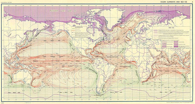
Datoteka:Ocean currents 1943.jpg
Prijeđi na navigaciju
Prijeđi na pretragu

Veličina ovog prikaza: 800 × 426 piksela. Druge rezolucije: 320 × 170 piksela | 640 × 341 piksela | 1.024 × 546 piksela | 1.280 × 682 piksela | 2.639 × 1.406 piksela.
Izvorna datoteka (2.639 × 1.406 piksela, veličina datoteke/fajla: 5,14 MB, MIME tip: image/jpeg)
Historija datoteke
Kliknite na datum/vrijeme da biste vidjeli tadašnju verziju datoteke.
| Datum/vrijeme | Minijatura | Dimenzije | Korisnik | Komentar | |
|---|---|---|---|---|---|
| aktualna | 12:58, 6 septembar 2016 |  | 2.639 × 1.406 (5,14 MB) | Dencey | new |
| 22:20, 31 mart 2005 |  | 2.639 × 1.406 (582 kB) | SEWilco | '''Ocean Currents and Sea Ice from Atlas of World Maps.''' United States Army Service Forces, Army Specialized Training Division. Army Service Forces Manual M-101. 1943 {{PD-PCL}} Source: http://www.lib.utexas.edu/maps/world_maps/ocean_currents_ |
Upotreba datoteke
Nema stranica koje koriste ovu datoteku.
Globalna upotreba datoteke
Ovu datoteku upotrebljavaju i sljedeći projekti:
- Upotreba na projektu bn.wikipedia.org
- Upotreba na projektu cs.wikipedia.org
- Upotreba na projektu de.wikipedia.org
- Upotreba na projektu en.wikipedia.org
- Upotreba na projektu eo.wikipedia.org
- Upotreba na projektu es.wikipedia.org
- Upotreba na projektu eu.wikipedia.org
- Upotreba na projektu fr.wikipedia.org
- Upotreba na projektu fr.wiktionary.org
- Upotreba na projektu hu.wikipedia.org
- Upotreba na projektu it.wikipedia.org
- Upotreba na projektu ja.wikipedia.org
- Upotreba na projektu lt.wikipedia.org
- Upotreba na projektu nn.wikipedia.org
- Upotreba na projektu oc.wikipedia.org
- Upotreba na projektu pt.wiktionary.org
- Upotreba na projektu sk.wikipedia.org
- Upotreba na projektu sl.wikipedia.org
- Upotreba na projektu sv.wikipedia.org
- Upotreba na projektu tr.wikipedia.org
- Upotreba na projektu vi.wikipedia.org
- Upotreba na projektu zh.wikipedia.org

