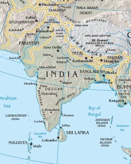
Datoteka:South asia.jpg
Izgled
South_asia.jpg (425 × 533 piksela, veličina datoteke/fajla: 52 kB, MIME tip: image/jpeg)
Historija datoteke
Kliknite na datum/vrijeme da biste vidjeli tadašnju verziju datoteke.
| Datum/vrijeme | Minijatura | Dimenzije | Korisnik | Komentar | |
|---|---|---|---|---|---|
| aktualna | 6. augusta 2008. u 17:59 |  | 425 × 533 (52 kB) | Deepak~commonswiki | |
| 27. jula 2008. u 01:48 |  | 421 × 541 (86 kB) | File Upload Bot (Magnus Manske) | {{BotMoveToCommons|en.wikipedia}} {{Information |Description={{en|<small>The image is cropped from en::Image:Sino-Indian Geography.png, created and published by the en:Central Intelligence Agency of the en:United States of America in [[:en |
Upotreba datoteke
Sljedećih 2 stranica koriste ovu datoteku:
Globalna upotreba datoteke
Ovu datoteku upotrebljavaju i sljedeći projekti:
- Upotreba na projektu ace.wikipedia.org
- Upotreba na projektu ar.wikipedia.org
- Upotreba na projektu ast.wikipedia.org
- Upotreba na projektu bg.wikipedia.org
- Upotreba na projektu bs.wikipedia.org
- Upotreba na projektu cy.wikipedia.org
- Upotreba na projektu en.wikipedia.org
- Upotreba na projektu es.wikipedia.org
- Upotreba na projektu id.wikipedia.org
- Upotreba na projektu incubator.wikimedia.org
- Upotreba na projektu jv.wikipedia.org
- Upotreba na projektu kn.wikipedia.org
- Upotreba na projektu la.wikipedia.org
- Upotreba na projektu ml.wikipedia.org
- Upotreba na projektu ms.wikipedia.org
- Upotreba na projektu pam.wikipedia.org
- Upotreba na projektu pl.wiktionary.org
- Upotreba na projektu pnb.wikipedia.org
- Upotreba na projektu rmy.wikipedia.org
- Upotreba na projektu ru.wikipedia.org
- Upotreba na projektu simple.wikipedia.org
- Upotreba na projektu sr.wikipedia.org
- Upotreba na projektu sv.wikipedia.org
- Upotreba na projektu ta.wikipedia.org
- Upotreba na projektu te.wikipedia.org
- Upotreba na projektu tl.wikipedia.org
- Upotreba na projektu tr.wikipedia.org
- Upotreba na projektu tr.wiktionary.org
- Upotreba na projektu war.wikipedia.org
- Upotreba na projektu www.wikidata.org
- Upotreba na projektu zh.wikipedia.org


