Datoteka:Types of offshore oil and gas structures.jpg
Prijeđi na navigaciju
Prijeđi na pretragu
Veća rezolucija nije dostupna.
Types_of_offshore_oil_and_gas_structures.jpg (600 × 236 piksela, veličina datoteke/fajla: 97 kB, MIME tip: image/jpeg)
Opis izmjene
| Opis |
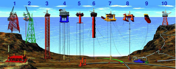
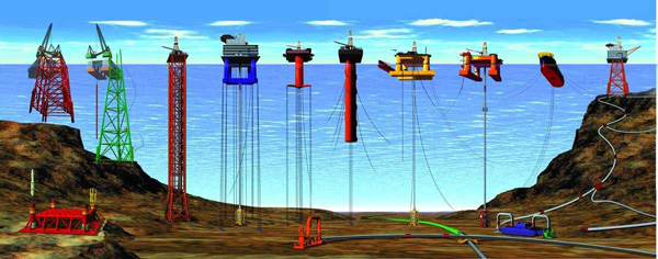
English: Types of Offshore Oil and Gas Structures
Deutsch: Arten von Öl- und Gasbohrinseln
|
| Datum | Revised at 15. decembar 2008. |
| Izvor | |
| Autor |
|
| Ostale verzije |
|

Licenciranje
Ova slika je u javnom vlasništvu jer sadrži materijale koji su izvorno iz Nacionalne oceanske i atmosferske administracije SAD, koja je nastala fotografiranjem ili izradom kao dio službenih dužnosti zaposlenika.
|
Historija datoteke
Kliknite na datum/vrijeme da biste vidjeli tadašnju verziju datoteke.
| Datum/vrijeme | Minijatura | Dimenzije | Korisnik | Komentar | |
|---|---|---|---|---|---|
| aktualna | 21:44, 25 oktobar 2013 | 600 × 236 (97 kB) | Jaybear | Numbers added; | |
| 19:56, 23 maj 2010 | 600 × 236 (72 kB) | Emerson7 | {{Information |Description = Types of offshore oil and gas structures incude: 1, 2) conventional fixed platforms (deepest: Shell’s Bullwinkle in 1991 at 412 m/1,353 ft GOM); 3) compliant tower (deepest: ChevronTexaco’s Petronius in 1998 at 534 m / |
Upotreba datoteke
Sljedeća stranica koristi ovu datoteku:
Globalna upotreba datoteke
Ovu datoteku upotrebljavaju i sljedeći projekti:
- Upotreba na projektu ar.wikipedia.org
- Upotreba na projektu cs.wikipedia.org
- Upotreba na projektu de.wikipedia.org
- Upotreba na projektu en.wikipedia.org
- Upotreba na projektu eo.wikipedia.org
- Upotreba na projektu es.wikipedia.org
- Upotreba na projektu fr.wikipedia.org
- Upotreba na projektu fy.wikipedia.org
- Upotreba na projektu gl.wikipedia.org
- Upotreba na projektu he.wikipedia.org
- Upotreba na projektu it.wikipedia.org
- Upotreba na projektu ja.wikipedia.org
- Upotreba na projektu nl.wikipedia.org
- Upotreba na projektu pl.wikipedia.org
- Upotreba na projektu pt.wikipedia.org
- Upotreba na projektu ru.wikipedia.org
- Upotreba na projektu sk.wikipedia.org
- Upotreba na projektu sl.wikipedia.org
- Upotreba na projektu tr.wikipedia.org
- Upotreba na projektu uk.wikipedia.org
- Upotreba na projektu vi.wikipedia.org
- Upotreba na projektu zh-yue.wikipedia.org
- Upotreba na projektu zh.wikipedia.org