Datoteka:Peloponnesian war alliances 431 BC.png
Prijeđi na navigaciju
Prijeđi na pretragu
Veličina ovog prikaza: 387 × 600 piksela. Druge rezolucije: 155 × 240 piksela | 482 × 747 piksela.
Izvorna datoteka (482 × 747 piksela, veličina datoteke/fajla: 37 kB, MIME tip: image/png)
Opis izmjene

|
Dostupna je vektorska inačica (SVG) ove slike. Trebala bi se koristiti umjesto ove rasterske slike ako je kvalitetnija.
File:Peloponnesian war alliances 431 BC.png → File:Guerre del Peloponneso 431aC mappa.svg
Za više informacija o vektorskoj grafici, pročitajte o prelasku Zajedničkog poslužitelja na SVG. Također pročitajte informacije o podršci MediaWiki softvera slikama u SVG formatu. |
 |
| Opis |
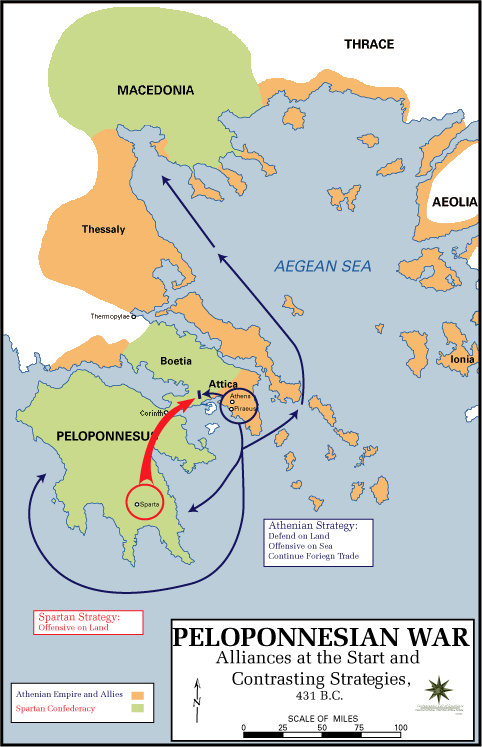
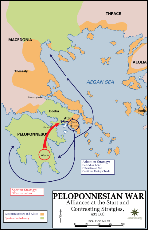
English: The Alliances of the Peloponnesian War |
| Datum | 5. maj 2009. (izvorni datum postavljanja) |
| Izvor |
|
| Autor | U.S. Army Cartographer, as amended by uploader to correct spelling mistake |
| Dopuštenje (Ponovna upotreba ove datoteke) |
Public domain as a work of the U.S. military.; amendments also released into the public domain |
| Ostale verzije |
|
Licenciranje
This work is in the public domain in the United States because it is a work prepared by an officer or employee of the United States Government as part of that person’s official duties under the terms of Title 17, Chapter 1, Section 105 of the US Code.
Note: This only applies to original works of the Federal Government and not to the work of any individual U.S. state, territory, commonwealth, county, municipality, or any other subdivision. This template also does not apply to postage stamp designs published by the United States Postal Service since 1978. (See § 313.6(C)(1) of Compendium of U.S. Copyright Office Practices). It also does not apply to certain US coins; see The US Mint Terms of Use.
|
 | |
| Ova datoteka je identificirana kao slobodna od poznatih ograničenja po zakonu o autorskim pravima, uključujući sva povezana i srodna prava. | ||
Izvorna evidencija postavljanja
Izvorna stranica s opisom bila je ovdje. Niže navedena suradnička imena odnose se na en.wikipedia.
- 2009-05-05 11:43 The Anome 482×747× (34269 bytes) Fixed second spelling mistake, which had been accidentally reinstated by reverting to original source.
- 2009-05-05 11:28 The Anome 482×747× (34263 bytes) {{Information |Description = The Alliances of the Peloponnesian War |Source = http://www.faculty.umb.edu/gary_zabel/Courses/Phil%20281b/Maps/peloponnesian_war_alliances.gif |Date = |Author = U.S. Army Cartographer, as ame
Historija datoteke
Kliknite na datum/vrijeme da biste vidjeli tadašnju verziju datoteke.
| Datum/vrijeme | Minijatura | Dimenzije | Korisnik | Komentar | |
|---|---|---|---|---|---|
| aktualna | 21:35, 30 mart 2018 | | 482 × 747 (37 kB) | Trecătorul răcit | Gulf of Pella in the time, position of names |
| 14:03, 5 maj 2009 |  | 482 × 747 (33 kB) | File Upload Bot (Magnus Manske) | {{BotMoveToCommons|en.wikipedia|year={{subst:CURRENTYEAR}}|month={{subst:CURRENTMONTHNAME}}|day={{subst:CURRENTDAY}}}} {{Information |Description={{en|The Alliances of the Peloponnesian War}} |Source=Transferred from [http://en.wikipedia.org en.wikipedia |
Upotreba datoteke
Sljedeća stranica koristi ovu datoteku:
Globalna upotreba datoteke
Ovu datoteku upotrebljavaju i sljedeći projekti:
- Upotreba na projektu ar.wikipedia.org
- Upotreba na projektu br.wikipedia.org
- Upotreba na projektu ca.wikipedia.org
- Upotreba na projektu da.wikipedia.org
- Upotreba na projektu el.wikipedia.org
- Upotreba na projektu en.wikipedia.org
- Upotreba na projektu et.wikipedia.org
- Upotreba na projektu eu.wikipedia.org
- Upotreba na projektu fa.wikipedia.org
- Upotreba na projektu fi.wikipedia.org
- Upotreba na projektu fr.wikipedia.org
- Upotreba na projektu hyw.wikipedia.org
- Upotreba na projektu id.wikibooks.org
- Upotreba na projektu it.wikipedia.org
- Upotreba na projektu ka.wikipedia.org
- Upotreba na projektu ko.wikipedia.org
- Upotreba na projektu lv.wikipedia.org
- Upotreba na projektu ml.wikipedia.org
- Upotreba na projektu ro.wikipedia.org
- Upotreba na projektu ru.wikipedia.org
- Upotreba na projektu sk.wikipedia.org
- Upotreba na projektu sq.wikipedia.org
- Upotreba na projektu sr.wikipedia.org
- Upotreba na projektu ta.wikipedia.org
- Upotreba na projektu th.wikipedia.org
- Upotreba na projektu tr.wikipedia.org
- Upotreba na projektu vi.wikipedia.org
- Upotreba na projektu xmf.wikipedia.org
- Upotreba na projektu yo.wikipedia.org
- Upotreba na projektu zh-yue.wikipedia.org
- Upotreba na projektu zh.wikipedia.org
- Upotreba na projektu zh.wikibooks.org