Datoteka:Michigan Basin 2.jpg
Michigan_Basin_2.jpg (357 × 360 piksela, veličina datoteke/fajla: 47 kB, MIME tip: image/jpeg)
Opis izmjene
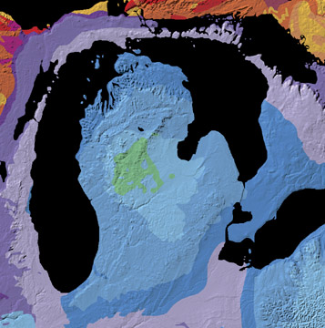
A geological map of the Michigan Basin.
Source: Michigan Basin archive copy at the Wayback Machine, The North American Tapestry of Time and Terrain, United States Department of the Interior. Text from this web page follows below.
A giant incomplete bull's-eye is centered on the state of Michigan. Radiating outward to Ohio, Indiana, Illinois, Wisconsin, and Ontario, this annular pattern outlines the Michigan Basin. The Basin is a bowl-shaped structure of uncertain origin that contains over 2.5 miles (4 km) of inward-dipping Paleozoic strata and a veneer of Jurassic sedimentary rocks. This curious basin is located in the less tectonically-active interior of the continent, bordered by the Appalachian and Rocky Mountains. It subsided rapidly from Cambrian to Silurian time and filled with shallow-water marine sediments, some of which contain deposits of petroleum, coal, and salt.
Licenciranje
This work is in the public domain in the United States because it is a work prepared by an officer or employee of the United States Government as part of that person’s official duties under the terms of Title 17, Chapter 1, Section 105 of the US Code.
Note: This only applies to original works of the Federal Government and not to the work of any individual U.S. state, territory, commonwealth, county, municipality, or any other subdivision. This template also does not apply to postage stamp designs published by the United States Postal Service since 1978. (See § 313.6(C)(1) of Compendium of U.S. Copyright Office Practices). It also does not apply to certain US coins; see The US Mint Terms of Use.
|
 | |
| Ova datoteka je identificirana kao slobodna od poznatih ograničenja po zakonu o autorskim pravima, uključujući sva povezana i srodna prava. | ||
Historija datoteke
Kliknite na datum/vrijeme da biste vidjeli tadašnju verziju datoteke.
| Datum/vrijeme | Minijatura | Dimenzije | Korisnik | Komentar | |
|---|---|---|---|---|---|
| aktualna | 13:29, 15 juni 2007 | | 357 × 360 (47 kB) | Avenue | A geological map of the Michigan Basin. Source: [http://nationalatlas.gov/articles/geology/features/michiganbasin.html Michigan Basin], The North American Tapestry of Time and Terrain, United States Department of the Interior. Text from this web page fo |
Upotreba datoteke
Sljedeća stranica koristi ovu datoteku:
Globalna upotreba datoteke
Ovu datoteku upotrebljavaju i sljedeći projekti:
- Upotreba na projektu ar.wikipedia.org
- Upotreba na projektu en.wikipedia.org
- Upotreba na projektu en.wikibooks.org
- Upotreba na projektu it.wikipedia.org
- Upotreba na projektu ru.wikipedia.org
- Upotreba na projektu sr.wikipedia.org
- Upotreba na projektu sv.wikipedia.org
- Upotreba na projektu www.wikidata.org