Datoteka:Grytviken-Location.jpg
Prijeđi na navigaciju
Prijeđi na pretragu

Veličina ovog prikaza: 800 × 560 piksela. Druge rezolucije: 320 × 224 piksela | 640 × 448 piksela | 1.024 × 717 piksela | 1.280 × 896 piksela | 2.165 × 1.516 piksela.
Izvorna datoteka (2.165 × 1.516 piksela, veličina datoteke/fajla: 1,48 MB, MIME tip: image/jpeg)
Opis izmjene
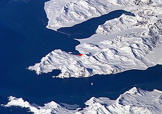
English: Satellite image of central South Georgia Island - in the Antarctic region.
- View of Cumberland Bay area, South Georgia Island: Thatcher Peninsula with King Edward Cove and Grytviken (red).
- Credits
- Fragment made by Apcbg.
- Image
- Science and Analysis Laboratory, NASA-Johnson Space Center. 25 Mar. 2005. "Astronaut Photography of Earth - Display Record."[1]
Source URL
Licenciranje
| This file is in the public domain in the United States because it was solely created by NASA. NASA copyright policy states that "NASA material is not protected by copyright unless noted". (See Template:PD-USGov, NASA copyright policy page or JPL Image Use Policy.) | ||
 |
Warnings:
|
Historija datoteke
Kliknite na datum/vrijeme da biste vidjeli tadašnju verziju datoteke.
| Datum/vrijeme | Minijatura | Dimenzije | Korisnik | Komentar | |
|---|---|---|---|---|---|
| aktualna | 11:19, 1 oktobar 2007 | | 2.165 × 1.516 (1,48 MB) | Apcbg | == Summary == Satellite image of Cumberland Bay area, South Georgia Island: Thatcher Peninsula with King Edward Cove and Grytviken. Fragment made by Apcbg. Image Science and Analysis Laboratory, NASA-Johnson Space Center. 25 Mar. 2005. "Astronaut Photog |
| 12:32, 27 maj 2006 |  | 2.093 × 1.495 (1,18 MB) | Apcbg | Satellite image of Cumberland Bay area, South Georgia Island: Thatcher Peninsula with King Edward Cove and Grytviken. Fragment made by Apcbg. Image Science and Analysis Laboratory, NASA-Johnson Space Center. 25 Mar. 2005. "Astronaut Photography of Earth |
Upotreba datoteke
Sljedeća stranica koristi ovu datoteku:
Globalna upotreba datoteke
Ovu datoteku upotrebljavaju i sljedeći projekti:
- Upotreba na projektu ang.wikipedia.org
- Upotreba na projektu ar.wikipedia.org
- Upotreba na projektu ast.wikipedia.org
- Upotreba na projektu az.wikipedia.org
- Upotreba na projektu bg.wikipedia.org
- Upotreba na projektu ca.wikipedia.org
- Upotreba na projektu ckb.wikipedia.org
- Upotreba na projektu en.wikipedia.org
- Upotreba na projektu es.wikipedia.org
- Upotreba na projektu fa.wikipedia.org
- Upotreba na projektu hr.wikipedia.org
- Upotreba na projektu id.wikipedia.org
- Upotreba na projektu it.wikipedia.org
- Upotreba na projektu lad.wikipedia.org
- Upotreba na projektu ms.wikipedia.org
- Upotreba na projektu nl.wikipedia.org
- Upotreba na projektu nn.wikipedia.org
- Upotreba na projektu no.wikipedia.org
- Upotreba na projektu ru.wikipedia.org
- Upotreba na projektu sk.wikipedia.org
- Upotreba na projektu sr.wikipedia.org
- Upotreba na projektu sv.wikipedia.org
- Upotreba na projektu ta.wikipedia.org
- Upotreba na projektu th.wikipedia.org
- Upotreba na projektu uk.wikipedia.org
- Upotreba na projektu zh.wikipedia.org