Datoteka:Economic region of Herzegovina.png
Prijeđi na navigaciju
Prijeđi na pretragu

Veličina ovog prikaza: 631 × 599 piksela. Druge rezolucije: 253 × 240 piksela | 505 × 480 piksela | 808 × 768 piksela | 1.078 × 1.024 piksela | 1.600 × 1.520 piksela.
Izvorna datoteka (1.600 × 1.520 piksela, veličina datoteke/fajla: 129 kB, MIME tip: image/png)
Opis izmjene
| Opis |
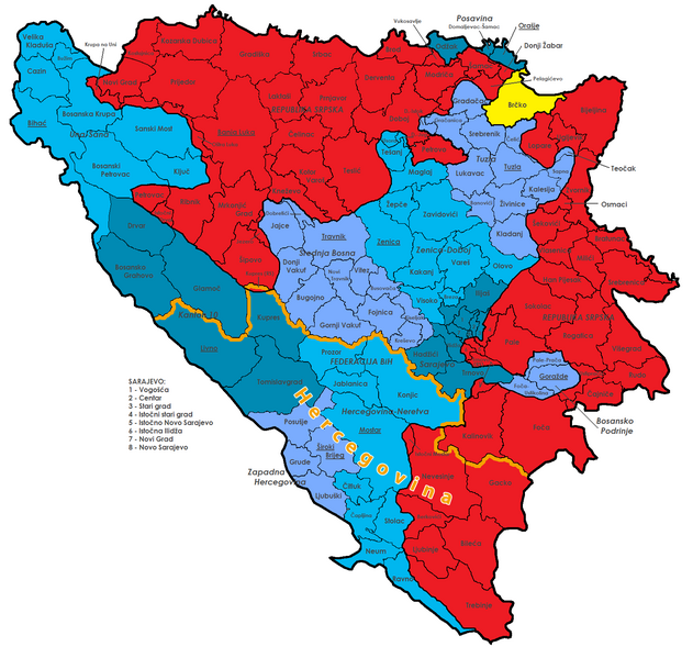
Deutsch: Diese Karte zeigt die Verwaltungsgliederung von Bosnien und Herzegowina. Dargestellt sind die Föderation BiH (blau) mit ihren Kantonen (verschiedene Schattierungen) und deren Hauptstädten, die Republika Srpska (rot), der Brčko-Distrikt (gelb) und alle Gemeinden mit ihren offiziellen Namen. Die Wirtschaftsregion Herzegowina ist orange abgegrenzt.
English: Map of the political division of Bosnia and Herzegovina; shows Federation Bih (blue) with cantons (different colours), Republika Srpska (red), Brčko district (yellow) and all municipalities with their official names. The Economical Region of Herzegovina is highlighted in orange. |
||
| Datum | (UTC) | ||
| Izvor |
|
||
| Autor |
|
||
| Ostale verzije |
|


|
This map has been made or improved in the German Kartenwerkstatt (Map Lab). You can propose maps to improve as well.
|
Licenciranje
Ova datoteka dostupna je pod licencom Creative Commons Attribution-Share Alike 3.0 Unported licencom.
- Slobodno smijete:
- dijeliti – umnožavati, raspodjeljivati i prenositi djelo
- prerađivati – prilagođavati djelo
- Pod sljedećim uslovima:
- pripisivanje – Morate pripisati odgovarajuće autorske zasluge, osigurati link ka licenci i naznačiti jesu li napravljene izmjene. To možete uraditi na bilo koji razumni način, ali ne tako da se sugerira da davalac licence odobrava Vas ili Vašu upotrebu njegovog djela.
- dijeljenje pod istim uslovima – Ako mijenjate, transformišete ili nadograđujete ovaj materijal, morate ga objaviti i distribuirati samo pod istom ili sličnom licencom poput ove.
Izvorna evidencija postavljanja
This image is a derivative work of the following images:
- File:Bosnia_and_Herzegovina_Political.png licensed with Cc-by-sa-3.0,2.5,2.0,1.0, GFDL
- 2009-07-18T16:15:19Z J budissin 1600x1520 (205343 Bytes) {{Information |Description= {{en|Map of the political division of Bosnia and Herzegovina; shows Federation Bih (blue) with cantons (different colours), Republika Srpska (red), Brčko district (yellow) and all municipalities w
Historija datoteke
Kliknite na datum/vrijeme da biste vidjeli tadašnju verziju datoteke.
| Datum/vrijeme | Minijatura | Dimenzije | Korisnik | Komentar | |
|---|---|---|---|---|---|
| aktualna | 21:37, 1 august 2013 | | 1.600 × 1.520 (129 kB) | NordNordWest | c |
| 21:49, 31 juli 2013 |  | 1.600 × 1.520 (128 kB) | NordNordWest | == {{int:filedesc}} == {{Information |Description={{de|Diese Karte zeigt die Verwaltungsgliederung von Bosnien und Herzegowina. Dargestellt sind die Föderation BiH (blau) mit ihren Kantonen (verschiedene Schattierungen) und deren Hauptstädten, die Re... |
Upotreba datoteke
Sljedeća stranica koristi ovu datoteku:
Globalna upotreba datoteke
Ovu datoteku upotrebljavaju i sljedeći projekti:
- Upotreba na projektu de.wikipedia.org
- Upotreba na projektu en.wikipedia.org
- Upotreba na projektu mk.wikipedia.org
- Upotreba na projektu sq.wikipedia.org