Datoteka:Cumbria UK location map.svg
Prijeđi na navigaciju
Prijeđi na pretragu

Veličina ovog PNG-pregleda ove SVG-datoteke: 508 × 599 piksela. Druge rezolucije: 203 × 240 piksela | 407 × 480 piksela | 651 × 768 piksela | 868 × 1.024 piksela | 1.736 × 2.048 piksela | 1.140 × 1.345 piksela.
Izvorna datoteka (SVG fajl, nominalno 1.140 × 1.345 piksela, veličina fajla: 2,05 MB)
| Opis |
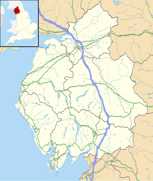
Map of Cumbria, UK with the following information shown:
Equirectangular map projection on WGS 84 datum, with N/S stretched 170% Geographic limits:
|
| Datum | |
| Izvor |
|
| Autor | Nilfanion, created using Ordnance Survey data |
| Dopuštenje (Ponovna upotreba ove datoteke) |
Ova datoteka dostupna je pod licencom Creative Commons Attribution-Share Alike 3.0 Unported licencom. Pripisivanje: Contains Ordnance Survey data © Crown copyright and database right
|
| Ostale verzije | File:Cumbria UK district map (blank).svg - Blank map |
.svg)
Historija datoteke
Kliknite na datum/vrijeme da biste vidjeli tadašnju verziju datoteke.
| Datum/vrijeme | Minijatura | Dimenzije | Korisnik | Komentar | |
|---|---|---|---|---|---|
| aktualna | 20:45, 26 septembar 2010 | | 1.140 × 1.345 (2,05 MB) | Nilfanion | {{Information |Description=Map of Cumbria, UK with the following information shown: *Administrative borders *Coastline, lakes and rivers *Roads and railways *Urban areas Equirectangular map projection on WGS 84 datum, with N/S stretched 170 |
Upotreba datoteke
Sljedeća stranica koristi ovu datoteku:
Globalna upotreba datoteke
Ovu datoteku upotrebljavaju i sljedeći projekti:
- Upotreba na projektu ar.wikipedia.org
- Upotreba na projektu bg.wikipedia.org
- Upotreba na projektu ceb.wikipedia.org
- Upotreba na projektu en.wikipedia.org
- Carlisle
- Cumbria
- Ulverston
- Cartmel Priory
- Thornhill, Cumbria
- Ambleside
- Time from NPL (MSF)
- Workington
- Millom
- Whitehaven
- Kendal
- Lakeside, Cumbria
- Keswick, Cumbria
- Appleby-in-Westmorland
- Barrow-in-Furness
- Cockermouth
- Aspatria
- Kirkby Lonsdale
- Windermere, Cumbria (town)
- Alston, Cumbria
- Grange-over-Sands
- Penrith, Cumbria
- Swarthmoor Hall
- Maryport
- Swarthmoor
- Vickers Shipbuilding and Engineering
- Grasmere (village)
- Burton-in-Kendal
- Hartley Castle
- King Arthur's Round Table
- Milnthorpe
- Long Meg and Her Daughters
- RAF Spadeadam
- Arnside
- Houghton, Cumbria
- RAF Carlisle
- Piel Island
- Greenodd
- Skelton Transmitting Station
- Dalton-in-Furness
- Anthorn Radio Station
- Hill Top, Cumbria
- Ravenglass
- Eskdale, Cumbria
- Wasdale Head
- Devil's Grinding Mill
- Kirkby Stephen