Datoteka:1951 CIA map of Syria – principal Arab and Kurdish tribes, 1951.jpg
Prijeđi na navigaciju
Prijeđi na pretragu

Veličina ovog prikaza: 737 × 600 piksela. Druge rezolucije: 295 × 240 piksela | 590 × 480 piksela | 944 × 768 piksela | 1.258 × 1.024 piksela | 2.516 × 2.048 piksela | 5.868 × 4.776 piksela.
Izvorna datoteka (5.868 × 4.776 piksela, veličina datoteke/fajla: 2,5 MB, MIME tip: image/jpeg)
Opis izmjene
| Opis |
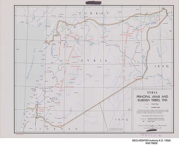
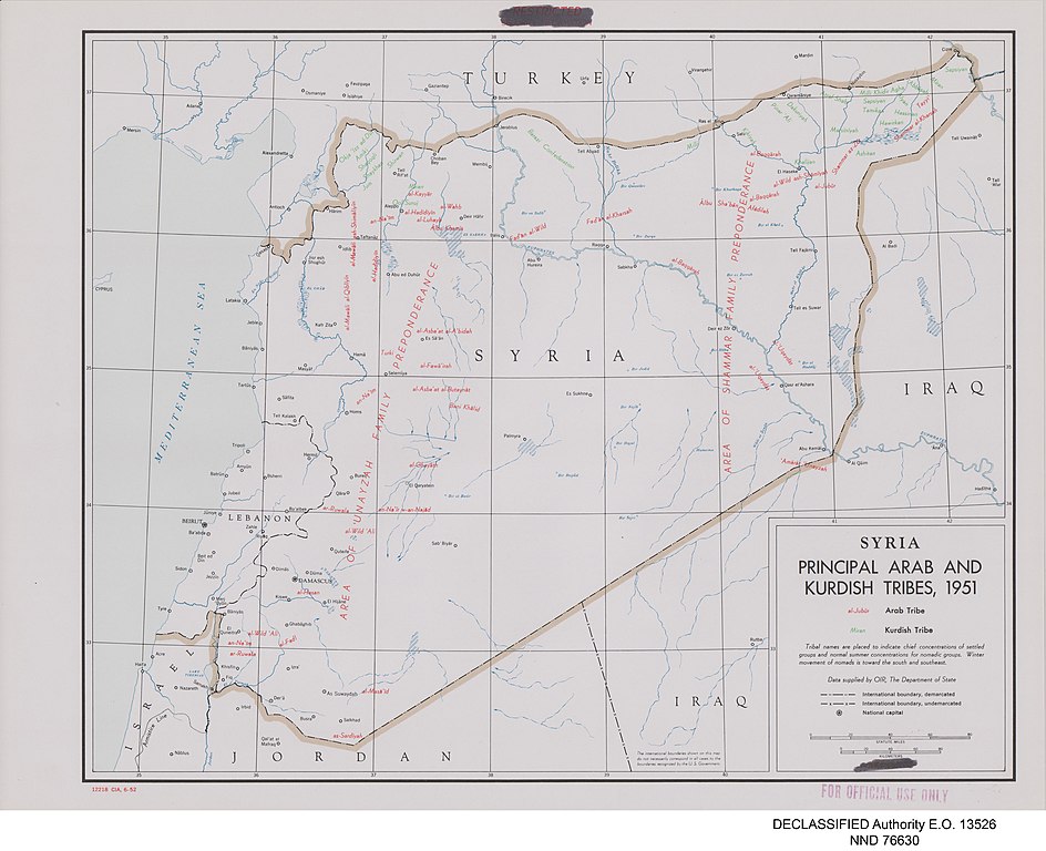
English: Map of Syria prepared by the United States Central Intelligence Agency's Map Branch in 1951. Names of Arab tribes are written in red; names of Kurdish tribes are in green. Marked in red at bottom left: "12218 CIA, 6-52", and top centre: "RESTRICTED" and "SECURITY INFORMATION" (struck through). Stamped "FOR OFFICIAL USE ONLY" in red, bottom right. In the map area itself, the word "RESTRICTED" in red has been deleted from the legend at the bottom right. In the bottom centre is printed: "The international boundaries shown on this map do not necessarily correspond in all cases to the boundaries recognized by the U.S. Government." Digitally added to the image, beneath the map: "DECLASSIFIED Authority E.O. 13526" and "NND 76630". |
| Datum | |
| Izvor |
United States National Archives Published Maps, 1947–2015 Record Group 263: Records of the Central Intelligence Agency, 1894–2002 https://catalog.archives.gov/id/175515101 (National Archives Identifier: 175515101) |
| Autor | Map Service Center, Central Intelligence Agency, United States National Security Council |
| Ostale verzije |
.jpg)
.jpg)
.jpg)
.jpg)
.jpg)
Licenciranje
| This image is a work of a Central Intelligence Agency employee, taken or made as part of that person's official duties. As a Work of the United States Government, this image or media is in the public domain in the United States.
|

|
Historija datoteke
Kliknite na datum/vrijeme da biste vidjeli tadašnju verziju datoteke.
| Datum/vrijeme | Minijatura | Dimenzije | Korisnik | Komentar | |
|---|---|---|---|---|---|
| aktualna | 06:32, 24 maj 2021 | | 5.868 × 4.776 (2,5 MB) | GPinkerton | Uploaded a work by Map Service Center, Central Intelligence Agency, United States National Security Council from United States National Archives Published Maps, 1947–2015 Record Group 263: Records of the Central Intelligence Agency, 1894–2002 https://catalog.archives.gov/id/175515101 (National Archives Identifier: 175515101) with UploadWizard |
Upotreba datoteke
Nema stranica koje koriste ovu datoteku.