Datoteka:1724 De L'Isle Map of Persia (Iran, Iraq, Afghanistan) - Geographicus - Persia-delisle-1724.jpg

Izvor: Wikipedija
Prijeđi na navigaciju Prijeđi na pretragu
Izvorna datoteka(4.500 × 3.553 piksela, veličina datoteke/fajla: 5,58 MB, MIME tip: image/jpeg)

Ova datoteka je s projekta Vikimedijina ostava i može se upotrebljavati i na drugim projektima. Ispod su prikazane informacije s njene opisne stranice.

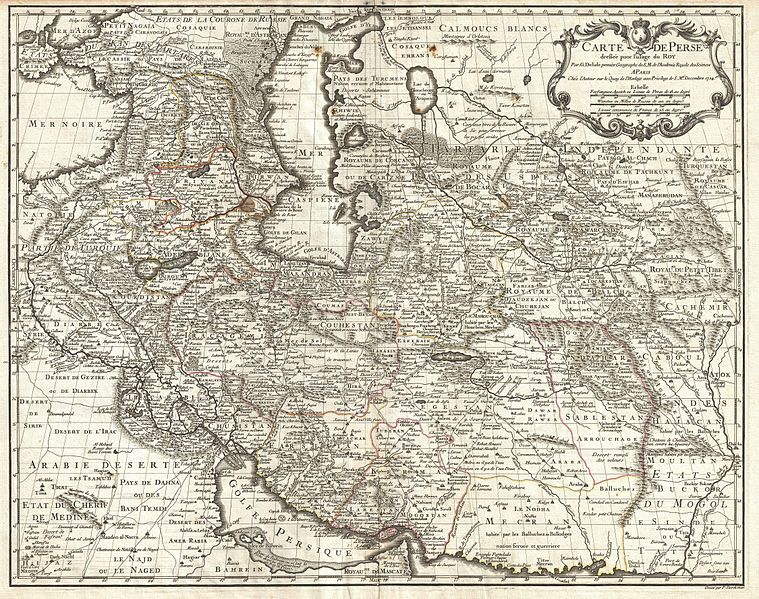
Carte de Perse, dressee pour l'usage du Roy. Par G. Delisle premier Geographe de S.M. de l'Academie Royale des Sciences.
Umetnik
Guillaume Delisle
Naslov
Carte de Perse, dressee pour l'usage du Roy. Par G. Delisle premier Geographe de S.M. de l'Academie Royale des Sciences.
Opis
English: A fine first edition example of Guillaume De L’Isle’s important 1724 map of Persia. Covers from the Crimea and the Sea of Azov south to the Persian Gulf and the Straight of Ormuz and east as far as Kashmir (Cachmir) and Kabul (Caboul). This map includes modern day Iran, Iraq, Afghanistan, Kuwait, Uzbekistan, Turkmenistan, Tajikistan, Georgia, Armenia, and Azerbaijan, with adjacent parts of Russia, Pakistan, Turkey, Ukraine, and Kazakhstan, and Arabia. Cartographically De L’Isle’s mapping of Persia marks a significant advance in European cartographic knowledge of the region. This map benefits considerably from Russian cartographic surveys and other sources no doubt smuggled to Guillaume De L’Isle by his brother Nicholas de L’Isle, who held a cartographic position with the Russian Academy of Sciences. The extent to which Russian data influenced this map is nowhere more evident than in De L’Isle’s remarkable rendering of the Caspian Sea – one of the first accurate maps of the great lake to follow Van Verden’s historic survey of 1721. Russian cartographic information is also apparent with regard to place names, such as the Russian name for the Aral Sea (Glouchoiye). It is equally likely that De L’Isle drew on Russian sources for his mapping of the Silk Route centers of Bukhara, Samarkand, and Ferghana, which were known stopping points for Russian trade envoys to China. For the remainder of Persia De L’Isle most likely updated Persian and Arabic cartographic information with reports from Georgian and Armenian traders and mercenaries active throughout Persia. It may be through these sources that De L’Isle was able to add considerable geographic information regarding trade routes and place names in central Persia. These include such significant advances as the identification of Terheran (Tiheran), the current capital of Iran, which is notable absent it earlier European maps of Persia. This map was drawn by Guillaume De L’Isle and engraved by P. Starckman. It issued independently as well as included in a number of composite atlases including De L’Isle’s 1731 Atlas de Geographie . A number of reissues by Buache, Covens & Mortier, and others followed.
Datum 1724 (undated)
Dimenzije visina: 20 in (50,8 cm); širina: 25 in (63,5 cm)
dimensions QS:P2048,20U218593
dimensions QS:P2049,25U218593
Popisni broj
Geographicus link: Persia-delisle-1724
Izvor/fotograf

De L'Isle, G., Atlas de Geographie, c. 1730.

Dopuštenje
(Ponovna upotreba ove datoteke)
This is a faithful photographic reproduction of a two-dimensional, public domain work of art. The work of art itself is in the public domain for the following reason:
Public domain

Ovo je djelo u javnom vlasništvu u zemlji podrijetla i u drugim zemljama s rokom trajanja autorskih prava za života autora plus 100 godina ili manje.


Morate dodati i oznaku javnog vlasništva za Sjedinjene Američke Države da bi se naznačilo zašto je ovo djelo u javnom vlasništvu u Sjedinjenim Američkim Državama.
The official position taken by the Wikimedia Foundation is that "faithful reproductions of two-dimensional public domain works of art are public domain".
This photographic reproduction is therefore also considered to be in the public domain in the United States. In other jurisdictions, re-use of this content may be restricted; see Reuse of PD-Art photographs for details.
Ostale verzije

Wikipedia

 Ovo je izabrana slika na Wikipediji na jeziku: perzijski (نگاره‌های برگزیده) i smatra se jednom od najboljih slika.

Ako smatrate da bi ova datoteka trebala biti izabrana također i na Zajedničkome poslužitelju, slobodno ju predložite.
Ako posjedujete fotografiju slične kvalitete koju ste voljni objaviti pod prikladnom licencijom, svakako ju postavite, propisno označite i predložite.

Opisi

Dodajte objašnjenje u jednom redu što predstavlja ova datoteka

Predmeti pokazani na ovoj datoteci

prikazuje

vrsta medija na Internetu Serbian (Latin script)

image/jpeg

kontrolna suma Srpski (transliteracija)

c369fa4e5652c19538b14f2755a70d576ca52710

veličina podatka Srpski (transliteracija)

5.855.771 Bajt

3.553 piksel

4.500 piksel

Historija datoteke

Kliknite na datum/vrijeme da biste vidjeli tadašnju verziju datoteke.

Datum/vrijemeMinijaturaDimenzijeKorisnikKomentar
aktualna05:53, 25 mart 2011Minijatura verzije (05:53, 25 mart 2011)4.500 × 3.553 (5,58 MB)BotMultichillT{{subst:User:Multichill/Geographicus |link=http://www.geographicus.com/P/AntiqueMap/Persia-delisle-1724 |product_name=1724 De L'Isle Map of Persia (Iran, Iraq, Afghanistan) |map_title=Carte de Perse, dressee pour l'usage du Roy. Par G. Delisle premier Geo

Sljedećih 2 stranica koriste ovu datoteku:

Globalna upotreba datoteke

Ovu datoteku upotrebljavaju i sljedeći projekti: