Datoteka:Yorkshire Dales map.xcf
Yorkshire_Dales_map.xcf (729 × 521 piksela, veličina datoteke/fajla: 686 kB, MIME tip: image/x-xcf)
|
|
| Opis |
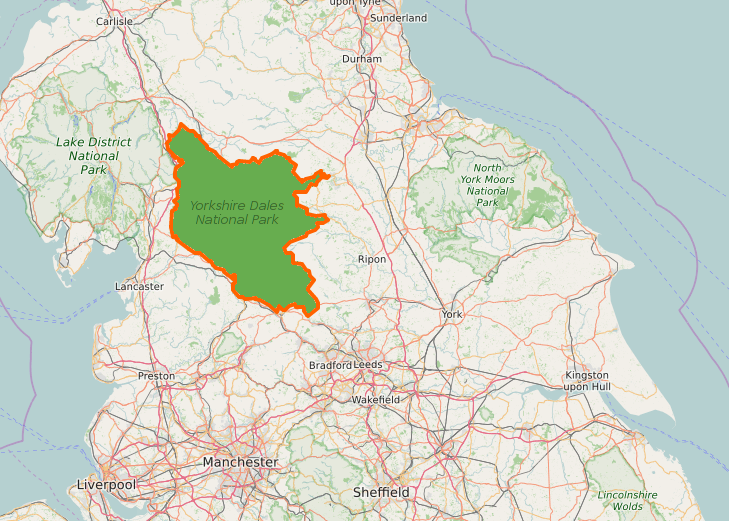
English: Overview map of the Yorkshire Dales National Park
Deutsch: Übersichtskarte des Yorkshire-Dales-Nationalparks |
|||||||||||||||
| Datum | ||||||||||||||||
| Izvor |
|
|||||||||||||||
| Autor | Kreuzschnabel | |||||||||||||||
| Dopuštenje (Ponovna upotreba ove datoteke) |
Ja, vlasnik autorskog prava ovog djela, ovdje ga objavljujem pod sljedećom licencom: Ova datoteka dostupna je pod licencom Creative Commons Attribution-Share Alike 3.0 Unported licencom.
|
|||||||||||||||
| XCF genesis |


Historija datoteke
Kliknite na datum/vrijeme da biste vidjeli tadašnju verziju datoteke.
| Datum/vrijeme | Minijatura | Dimenzije | Korisnik | Komentar | |
|---|---|---|---|---|---|
| aktualna | 07:53, 27 august 2016 |  | 729 × 521 (686 kB) | Kreuzschnabel | {{Information |Description ={{en|1=Overview map of the Yorkshire Dales National Park}} {{de|1=Übersichtskarte des Yorkshire-Dales-Nationalparks}} |Source ={{Openstreetmap}} |Author =Kreuzschnabel |Date... |
Upotreba datoteke
Sljedeća stranica koristi ovu datoteku: