Datoteka:Shepherd Map of Ancient Italy, Northern Part.jpg
Izvorna datoteka (1.820 × 1.480 piksela, veličina datoteke/fajla: 1,21 MB, MIME tip: image/jpeg)
Opis izmjene
| Opis |
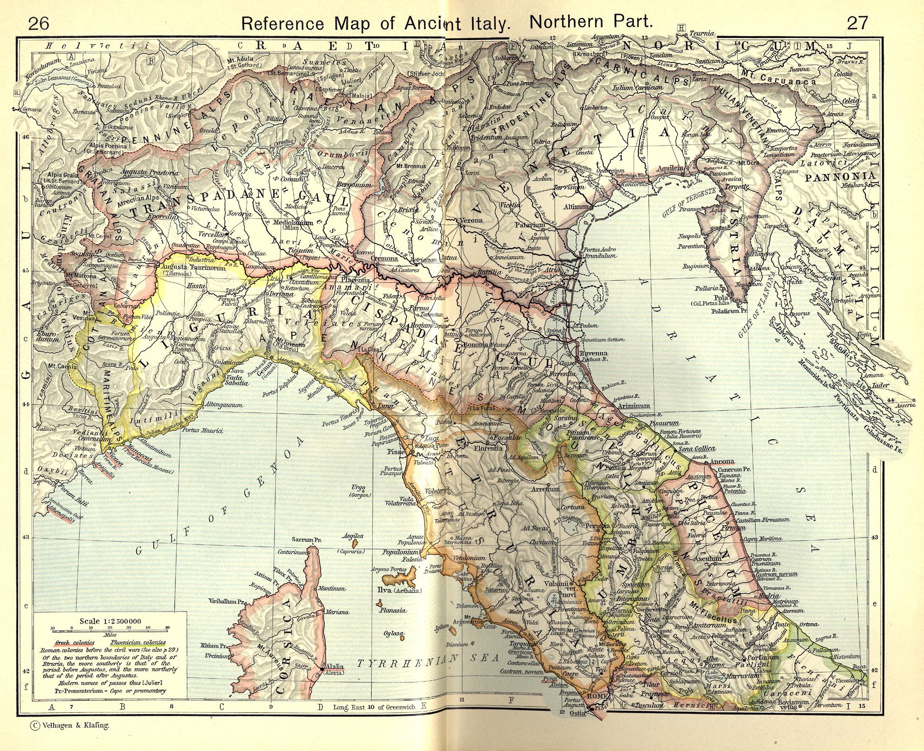
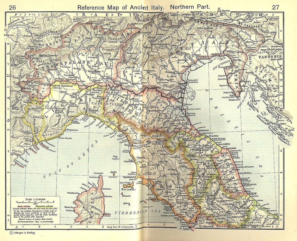
English: Reference Map of Ancient Italy, Northern Part [1]
Historical Atlas by William R. Shepherd, 1911. Courtesy of the University of Texas Libraries, The University of Texas at Austin. From The Historical Atlas by William R. Shepherd, 1911 edition |
| Datum | 7. mart 2008. (datum postavljanja) |
| Izvor | Historical Atlas by William R. Shepherd 1911 edition |
| Autor | Historical Atlas by William R. Shepherd 1911 edition |
| Dopuštenje (Ponovna upotreba ove datoteke) |
This image is in the public domain due to its age. See also http://www.lib.utexas.edu/usage_statement.html?maps=yes |
| Ostale verzije | Radovi izvedeni od ove datoteke: Ancient Umbria.png |
![[1]](http://www.lib.utexas.edu/maps/historical/shepherd_1911/shepherd-c-026-027.jpg)
Licenciranje
|
Ovo je djelo u javnom vlasništvu u zemlji podrijetla i u drugim zemljama s rokom trajanja autorskih prava za života autora plus 70 godina ili manje.
| |
| Ova datoteka je identificirana kao slobodna od poznatih ograničenja po zakonu o autorskim pravima, uključujući sva povezana i srodna prava. | |
This media file is in the public domain in the United States. This applies to U.S. works where the copyright has expired, often because its first publication occurred prior to January 1, 1929, and if not then due to lack of notice or renewal. See this page for further explanation.
|
 | |
 |
This image might not be in the public domain outside of the United States; this especially applies in the countries and areas that do not apply the rule of the shorter term for US works, such as Canada, Mainland China (not Hong Kong or Macao), Germany, Mexico, and Switzerland. The creator and year of publication are essential information and must be provided. See Wikipedia:Public domain and Wikipedia:Copyrights for more details.
|
Historija datoteke
Kliknite na datum/vrijeme da biste vidjeli tadašnju verziju datoteke.
| Datum/vrijeme | Minijatura | Dimenzije | Korisnik | Komentar | |
|---|---|---|---|---|---|
| aktualna | 20:52, 19 juli 2010 | | 1.820 × 1.480 (1,21 MB) | Cropbot | upload cropped version, operated by User:Beao. Summary: cropped |
| 10:02, 1 juli 2007 |  | 1.902 × 1.545 (831 kB) | Accurimbono | == Summary == Map of Northen Italy during the Roman period. Extracted from ''The Historical Atlas'' by William R. Shepherd, 1911. Original image is at http://www.lib.utexas.edu/maps/historical/shepherd_1911/shepherd-c-026-027.jpg [ |
Upotreba datoteke
Sljedeća stranica koristi ovu datoteku:
Globalna upotreba datoteke
Ovu datoteku upotrebljavaju i sljedeći projekti:
- Upotreba na projektu ast.wikipedia.org
- Upotreba na projektu bg.wikipedia.org
- Upotreba na projektu br.wikipedia.org
- Upotreba na projektu ca.wikipedia.org
- Upotreba na projektu cs.wikipedia.org
- Upotreba na projektu de.wikipedia.org
- Upotreba na projektu en.wikipedia.org
- Upotreba na projektu es.wikipedia.org
- Upotreba na projektu et.wikipedia.org
- Upotreba na projektu fr.wikipedia.org
- Upotreba na projektu it.wikipedia.org