Datoteka:Operation Dragoon - map.jpg
Izvorna datoteka (1.265 × 965 piksela, veličina datoteke/fajla: 1,94 MB, MIME tip: image/jpeg)

|
This military map image could be re-created using vector graphics as an SVG file. This has several advantages; see Commons:Media for cleanup for more information. If an SVG form of this image is available, please upload it and afterwards replace this template with
{{vector version available|new image name}}.
It is recommended to name the SVG file “Operation Dragoon - map.svg”—then the template Vector version available (or Vva) does not need the new image name parameter. |


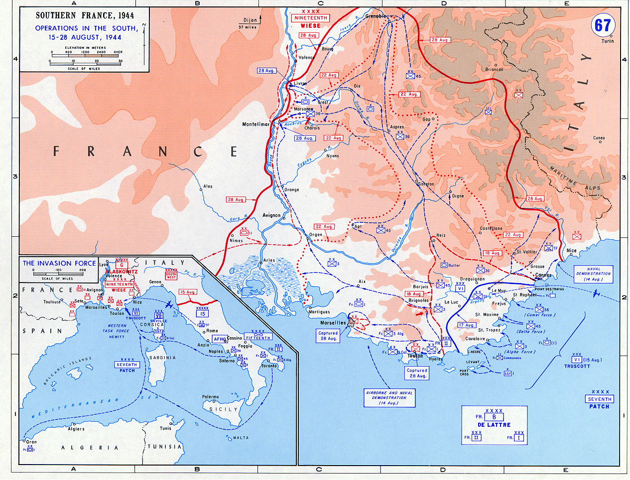
- Description: Operation Dragoon - Aug. 1944
- Source: www.dean.usma.edu
- Background information:
In 1938 the predecessors of what is today The Department of History at the United States Military Academy began developing a series of campaign atlases to aid in teaching cadets a course entitled, "History of the Military Art." Since then, the Department has produced over six atlases and more than one thousand maps, encompassing not only America’s wars but global conflicts as well.
In keeping abreast with today's technology, the Department of History is providing these maps on the internet as part of the department's outreach program. The maps were created by the United States Military Academy’s Department of History and are the digital versions from the atlases printed by the United States Defense Printing Agency. We gratefully acknowledge the accomplishments of the department's former cartographer, Mr. Edward J. Krasnoborski, along with the works of our present cartographer, Mr. Frank Martini.
Please be aware that these maps are large in file size and may require substantial download times.
Notes
- The indication "Dijon 37 miles" in the top middle of the map is most likely an error and should read "Lyon 37 miles".
Ova je slika djelo pripadnika ili zaposlenika Oružanih snaga SAD-a načinjena u vrijeme obavljanja službe. Kao djelo američke savezne vlade, slika je u javnom vlasništvu.
|
 |
Historija datoteke
Kliknite na datum/vrijeme da biste vidjeli tadašnju verziju datoteke.
| Datum/vrijeme | Minijatura | Dimenzije | Korisnik | Komentar | |
|---|---|---|---|---|---|
| aktualna | 18:50, 23 maj 2018 | | 1.265 × 965 (1,94 MB) | Hohum | Colour adjust |
| 19:53, 14 septembar 2005 |  | 1.265 × 965 (1,93 MB) | W.wolny |
Upotreba datoteke
Sljedeća stranica koristi ovu datoteku:
Globalna upotreba datoteke
Ovu datoteku upotrebljavaju i sljedeći projekti:
- Upotreba na projektu azb.wikipedia.org
- Upotreba na projektu bg.wikipedia.org
- Upotreba na projektu ca.wikipedia.org
- Upotreba na projektu cs.wikipedia.org
- Upotreba na projektu da.wikipedia.org
- Upotreba na projektu de.wikipedia.org
- Upotreba na projektu el.wikipedia.org
- Upotreba na projektu en.wikipedia.org
- Upotreba na projektu eo.wikipedia.org
- Upotreba na projektu es.wikipedia.org
- Upotreba na projektu fa.wikipedia.org
- Upotreba na projektu fi.wikipedia.org
- Upotreba na projektu fr.wikipedia.org
- Upotreba na projektu he.wikipedia.org
- Upotreba na projektu hu.wikipedia.org
- Upotreba na projektu id.wikipedia.org
- Upotreba na projektu it.wikipedia.org
- Upotreba na projektu ja.wikipedia.org
- Upotreba na projektu ko.wikipedia.org
- Upotreba na projektu nl.wikipedia.org
- Upotreba na projektu no.wikipedia.org
- Upotreba na projektu pl.wikipedia.org
- Upotreba na projektu ro.wikipedia.org
- Upotreba na projektu ru.wikipedia.org
- Upotreba na projektu sk.wikipedia.org
- Upotreba na projektu sl.wikipedia.org
- Upotreba na projektu sv.wikipedia.org
- Upotreba na projektu ta.wikipedia.org
- Upotreba na projektu th.wikipedia.org
- Upotreba na projektu tr.wikipedia.org
- Upotreba na projektu uk.wikipedia.org
- Upotreba na projektu www.wikidata.org
- Upotreba na projektu zh.wikipedia.org