Datoteka:Kandahar districts.png
Prijeđi na navigaciju
Prijeđi na pretragu

Veličina ovog prikaza: 786 × 600 piksela. Druge rezolucije: 315 × 240 piksela | 629 × 480 piksela | 1.000 × 763 piksela.
Izvorna datoteka (1.000 × 763 piksela, veličina datoteke/fajla: 30 kB, MIME tip: image/png)

|
This locator map image could be re-created using vector graphics as an SVG file. This has several advantages; see Commons:Media for cleanup for more information. If an SVG form of this image is available, please upload it and afterwards replace this template with
{{vector version available|new image name}}.
It is recommended to name the SVG file “Kandahar districts.svg”—then the template Vector version available (or Vva) does not need the new image name parameter. |
Opis izmjene

|
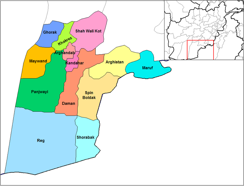
This file requires updating because: Does not include Miyanishin District or Zhari District. Miyanishin was created from the Northern part of Shah Wali Kot. Zhari was created from parts of Maywand and Panjwai In doing so, you could add a timestamp to the file.
|
English: Map of the districts of Kandahar province of Afghanistan. Created by Rarelibra 19:26, 29 March 2007 (UTC) for public domain use, using MapInfo Professional v8.5 and various mapping resources.
Licenciranje
| Ja, vlasnik autorskog prava ovog djela, objavljujem ovaj rad u javno vlasništvo. Ovo se primjenjuje u cijelom svijetu. U nekim državama ovo zakonski nije moguće; u tom slučaju: Ja dopuštam svima pravo korištenja ovog rada u bilo koju svrhu, bez ikakvih uslova, osim ako su takvi uslovi zakonski neophodni. |
Historija datoteke
Kliknite na datum/vrijeme da biste vidjeli tadašnju verziju datoteke.
| Datum/vrijeme | Minijatura | Dimenzije | Korisnik | Komentar | |
|---|---|---|---|---|---|
| aktualna | 16:47, 15 februar 2024 | | 1.000 × 763 (30 kB) | User-duck | Cropped 5 % horizontally, 6 % vertically using CropTool with lossless mode. |
| 21:26, 29 mart 2007 |  | 1.056 × 816 (30 kB) | Rarelibra | Map of the districts of Kandahar province of Afghanistan. Created by ~~~~ for public domain use, using MapInfo Professional v8.5 and various mapping resources. |
Upotreba datoteke
Sljedeća stranica koristi ovu datoteku:
Globalna upotreba datoteke
Ovu datoteku upotrebljavaju i sljedeći projekti:
- Upotreba na projektu ar.wikipedia.org
- Upotreba na projektu bn.wikipedia.org
- Upotreba na projektu ca.wikipedia.org
- Upotreba na projektu da.wikipedia.org
- Upotreba na projektu de.wikipedia.org
- Upotreba na projektu en.wikipedia.org
- Upotreba na projektu en.wikinews.org
- Upotreba na projektu es.wikipedia.org
- Upotreba na projektu et.wikipedia.org
- Upotreba na projektu fr.wikipedia.org
- Upotreba na projektu he.wikipedia.org
- Upotreba na projektu incubator.wikimedia.org
- Upotreba na projektu it.wikipedia.org
- Upotreba na projektu ja.wikipedia.org
- Upotreba na projektu lt.wikipedia.org
- Upotreba na projektu mn.wikipedia.org
- Upotreba na projektu ms.wikipedia.org
- Upotreba na projektu nl.wikipedia.org