Datoteka:Intracoastal Waterway at Bayou Barataria.jpg
Prijeđi na navigaciju
Prijeđi na pretragu
Veličina ovog prikaza: 800 × 533 piksela. Druge rezolucije: 320 × 213 piksela | 640 × 427 piksela | 1.024 × 683 piksela | 1.500 × 1.000 piksela.
Izvorna datoteka (1.500 × 1.000 piksela, veličina datoteke/fajla: 396 kB, MIME tip: image/jpeg)
| Opis |
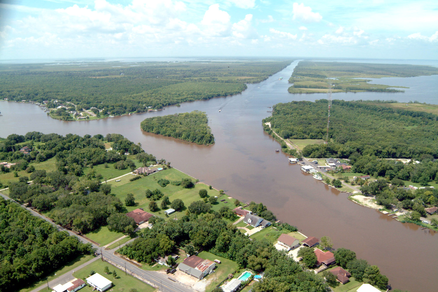
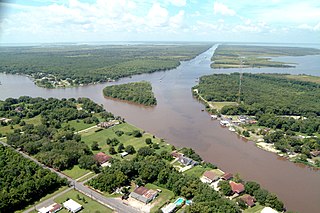
English: Aerial view of a northern section of Jean Lafitte, Louisiana at the Gulf Intracoastal Waterway (GIWW). The waterway stretches off to the southwest at the top of the picture and also turns right into the Bayou Villars and Lake Salvador at the right. Bayou Barataria runs off to the left. |
|||
| Datum | ||||
| Izvor |
U.S. Army Corps of Engineers Digital Visual Library Image page Image description page Digital Visual Library home page |
|||
| Autor | Lane Lefort, U.S. Army Corps of Engineers | |||
| Dopuštenje (Ponovna upotreba ove datoteke) |
|
|||
| Lokacija | Jefferson Parish, Louisiana |
| Lokacija kamere | | Ova i druge slike na njihovim lokacijama na: OpenStreetMap |
|---|
Historija datoteke
Kliknite na datum/vrijeme da biste vidjeli tadašnju verziju datoteke.
| Datum/vrijeme | Minijatura | Dimenzije | Korisnik | Komentar | |
|---|---|---|---|---|---|
| aktualna | 01:23, 8 april 2007 | | 1.500 × 1.000 (396 kB) | DanMS | {{Information | Description = {{en|Aerial view of a northern section of Jean Lafitte, Louisiana at the Gulf Intracoastal Waterway (GIWW). The waterway stretches off to the southwest at the top of the picture and also turns right into the Bayou Villars |
Upotreba datoteke
Sljedeća stranica koristi ovu datoteku:
Globalna upotreba datoteke
Ovu datoteku upotrebljavaju i sljedeći projekti:
- Upotreba na projektu ar.wikipedia.org
- Upotreba na projektu arz.wikipedia.org
- Upotreba na projektu azb.wikipedia.org
- Upotreba na projektu ca.wikipedia.org
- Upotreba na projektu ceb.wikipedia.org
- Upotreba na projektu ce.wikipedia.org
- Upotreba na projektu cy.wikipedia.org
- Upotreba na projektu en.wikipedia.org
- Upotreba na projektu en.wikivoyage.org
- Upotreba na projektu es.wikipedia.org
- Upotreba na projektu eu.wikipedia.org
- Upotreba na projektu fa.wikipedia.org
- Upotreba na projektu fr.wikipedia.org
- Upotreba na projektu ht.wikipedia.org
- Upotreba na projektu it.wikipedia.org
- Upotreba na projektu lld.wikipedia.org
- Upotreba na projektu nl.wikipedia.org
- Upotreba na projektu pl.wikipedia.org
- Upotreba na projektu pt.wikipedia.org
- Upotreba na projektu sr.wikipedia.org
- Upotreba na projektu tt.wikipedia.org
- Upotreba na projektu uk.wikipedia.org
- Upotreba na projektu www.wikidata.org
- Upotreba na projektu zh-min-nan.wikipedia.org