Datoteka:Indian Rashtrakuta Empire map.svg

Izvorna datoteka (SVG fajl, nominalno 1.639 × 1.852 piksela, veličina fajla: 410 kB)
| Naslov |
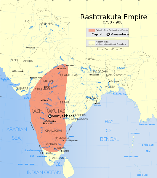
The Rashtrakuta Empire 750-900BC |
|||||||||
| Opis |
Map showing the extent of the Rashtrakuta empires. Extent of Rashtrakuta Empire, 780 C.E. |
|||||||||
| Map legend |
 |
|||||||||
| Datum | ||||||||||
| Izvor |
Vlastito djelo |
|||||||||
| Kreator | ||||||||||
| Dopuštenje (Ponovna upotreba ove datoteke) |
Ja, vlasnik autorskog prava ovog djela, ovdje ga objavljujem pod sljedećom licencom: Ova datoteka dostupna je pod licencom Creative Commons Attribution-Share Alike 3.0 Unported licencom.
|
|||||||||
| Geotemporal data | ||||||||||
| Prikaz se dešava u vremenu | druga polovina 20. stoljeće i 21. stoljeće | |||||||||
| Prostorni referentni sisem | conic | |||||||||
| Bounding box |
|
|||||||||
| Georeferencing | If inappropriate please set warp_status = skip to hide. | |||||||||
| Archival data | ||||||||||
| Beleške | Part of WikiProject India Maps | |||||||||

Notes
Depiction of India's borders
- The territorial boundaries of India are shown as per the actual ground situation in accordance with international practices followed by the United Nations ([1], [2]) and the National Geographic Society ([3], [4])
- This map is meant to be for illustrative purpose only and is not authenticated by official government sources. Please check the list of sources and references used to create the map for a measure of accuracy and verifiability.
- The usage of these maps in India, Pakistan and China are governed by different laws that restrict depictions of boundaries other than what is officially recognized by the state. Please check local laws and modify the map accordingly before use.
Explanation of disputed boundaries


- Boundary of Indian claim : The territory India claims is legally theirs, but the claim is disputed by China and Pakistan.
- Line of Control/Line of Conflict : The de facto administrative boundary recognised by the international community. This UN ceasefire line is considered as a temporary solution to an ongoing conflict since the departure of the British Raj.
Borders of disputed regions
The depicted extent of the former territory of the British Indian Empire, succeeded by Republic of India, may not be accepted by few countries as legal due to ongoing border disputes:
- The northern Himalayan region of the disputed territory Indian-administered Kashmir is claimed by India including (Pakistan-administered Kashmir) and the Chinese-occupied territory of (Ladakh plateau). Since 1972, it is divided between all three countries. See also Line of Control and Line of Actual Control.
- Siachen glacier (shown white) is an actively contested region between India and Pakistan. Since 1984, the region is under Indian control.
- The northeastern territory of Arunachal Pradesh is almost entirely claimed by China as part of its Tibetan territory.
- Minor areas of eastern Kashmir's Ladakh division, Himachal Pradesh and Uttarakhand on the Chinese frontier are claimed by China. These areas are under Indian control.
- A small area of Uttarakhand adjoining the Nepal border along the Sarda river is disputed between the two countries.
For a detailed map of all disputed regions in South Asia, see Image:India disputed areas map.svg
Internal borders
The borders of the state of Meghalaya, Assam and Arunachal Pradesh are shown as interpreted from the North-Eastern Areas (Reorganisation) Act, 1971, but has yet to be verified.
Territorial waters
The limit of the territorial waters of India extends to twelve nautical miles measured from the appropriate baseline. See this for more information.
derivative works
Radovi izvedeni od ove datoteke:
Historija datoteke
Kliknite na datum/vrijeme da biste vidjeli tadašnju verziju datoteke.
| Datum/vrijeme | Minijatura | Dimenzije | Korisnik | Komentar | |
|---|---|---|---|---|---|
| aktualna | 04:47, 9 juli 2013 | | 1.639 × 1.852 (410 kB) | AnonMoos | remove Adobe cruft |
| 20:57, 27 april 2007 |  | 1.639 × 1.852 (451 kB) | Planemad | {{WikiProject_India_Maps |Title=The Rashtrakuta Empire 750-900BC |Description=Map showing the extent of the Rashtrakuta empires. {{legend|#FF9F80|Extent of Rashtrakuta Empire, 780 C.E.}} |Source= "John Keay, History of India, 2000, Grove publications, Ne |
Upotreba datoteke
Sljedeća stranica koristi ovu datoteku:
Globalna upotreba datoteke
Ovu datoteku upotrebljavaju i sljedeći projekti:
- Upotreba na projektu ar.wikipedia.org
- Upotreba na projektu azb.wikipedia.org
- Upotreba na projektu ba.wikipedia.org
- Upotreba na projektu bn.wikipedia.org
- Upotreba na projektu br.wikipedia.org
- Upotreba na projektu ca.wikipedia.org
- Upotreba na projektu en.wikipedia.org
- Middle kingdoms of India
- Timeline of scientific discoveries
- Portal:India
- Rashtrakuta Empire
- Shilahara
- North Karnataka
- Wikipedia talk:WikiProject Indian maps
- History of Karnataka
- Portal:India/Selected articles/Archive
- Political history of medieval Karnataka
- Portal:India/SC Summary/SA Rashtrakuta Dynasty
- Chalukyas of Vemulavada
- List of Hindu empires and dynasties
- Upotreba na projektu en.wiktionary.org
- Upotreba na projektu fa.wikipedia.org
- Upotreba na projektu fi.wikipedia.org
- Upotreba na projektu fr.wikipedia.org
- Upotreba na projektu gu.wikipedia.org
- Upotreba na projektu hi.wikipedia.org
- Upotreba na projektu hu.wikipedia.org
- Upotreba na projektu hy.wikipedia.org
- Upotreba na projektu id.wikipedia.org
- Upotreba na projektu it.wikipedia.org
- Upotreba na projektu ja.wikipedia.org
- Upotreba na projektu ka.wikipedia.org
- Upotreba na projektu kn.wikipedia.org
- Upotreba na projektu ko.wikipedia.org
- Upotreba na projektu lt.wikipedia.org
- Upotreba na projektu ml.wikipedia.org
- Upotreba na projektu mr.wikipedia.org
- Upotreba na projektu ms.wikipedia.org
- Upotreba na projektu ne.wikipedia.org