Datoteka:Europe 1748-1766 en.png
Prijeđi na navigaciju
Prijeđi na pretragu

Veličina ovog prikaza: 800 × 570 piksela. Druge rezolucije: 320 × 228 piksela | 640 × 456 piksela | 1.024 × 730 piksela | 1.280 × 913 piksela | 2.560 × 1.825 piksela | 3.872 × 2.761 piksela.
Izvorna datoteka (3.872 × 2.761 piksela, veličina datoteke/fajla: 1,26 MB, MIME tip: image/png)

|
This map of europe image could be re-created using vector graphics as an SVG file. This has several advantages; see Commons:Media for cleanup for more information. If an SVG form of this image is available, please upload it and afterwards replace this template with
{{vector version available|new image name}}.
It is recommended to name the SVG file “Europe 1748-1766 en.svg”—then the template Vector version available (or Vva) does not need the new image name parameter. |
_en.png)
.png)
.jpg)
Opis izmjene
| Opis |
Deutsch: Diese Karte zeigt Europa in den Jahren nach dem Frieden von Aachen 1748 und in der Zeit des Siebenjährigen Krieges (1756-1763). Bis 1766 kam es zu keinen größeren geographischen Veränderungen in Europa.
Die Arbeit wurde mit Inkscape erstellt und beruht hauptsächlich auf einer Karte in: Putzger - Historischer Weltatlas, Berlin 1990, S.78f.
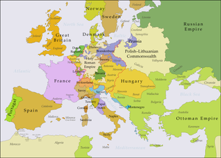
English: This map shows Europe in the years after the Treaty of Aix-la-Chapelle 1748 and the Seven Years' War (1756-1763). Europe did not see another major geographical change until 1766. The red line marks the borders of the Holy Roman Empire.
The work was created with Inkscape and is mainly based on a map in: Putzger - Historischer Weltatlas, Berlin 1990, 78 pp.
Français : Cette carte montre l'Europe dans les années après le Traité d'Aix-la-Chapelle (1748) et pendant les années de la Guerre des Sept Ans (1756-1763). L'Europe n'a pas vu un autre changement géographique important jusqu'à 1766.
Le travail a été créé avec Inkscape et il est basé principalement sur une carte dans: Putzger - Historischer Weltatlas, Berlin 1990, 78 pp.
Polski: Ta mapa ukazuje Europę w latach po pokoju w Akwizgranie z 1748 i wojnie siedmioletniej (1756-1763). Europa nie uświadczyła żadnych poważniejszych zmian geograficznych aż do 1766. Czerwona linia znaczy granice Świętego Cesarstwa Rzymskiego.
Praca została stworzona z użyciem Inkscape i powstała głównie na bazie mapy w: Putzger - Historischer Weltatlas, Berlin 1990, 78 pp.
Русский: Эта карта представляет Европу после заключения Аахенского мира в 1748 г. и во время Семилетней войны (1756-1763 гг.). До 1766 г. эта картина Европы не исменилась.
Эта работа нарисована с помощью программы Inkscape и основана на карте из книги: Putzger - Historischer Weltatlas, Berlin 1990, 78 cc. |
| Datum | |
| Izvor |
Ova je datoteka izvedena iz: Europe 1748-1766.png |
| Autor | P. S. Burton |
Licenciranje
Ja, vlasnik autorskog prava ovog djela, ovdje ga objavljujem pod sljedećom licencom:
Ova datoteka je licencirana pod Creative Commons Attribution 3.0 neportiranom licencom.
- Slobodno smijete:
- dijeliti – umnožavati, raspodjeljivati i prenositi djelo
- prerađivati – prilagođavati djelo
- Pod sljedećim uslovima:
- pripisivanje – Morate pripisati odgovarajuće autorske zasluge, osigurati link ka licenci i naznačiti jesu li napravljene izmjene. To možete uraditi na bilo koji razumni način, ali ne tako da se sugerira da davalac licence odobrava Vas ili Vašu upotrebu njegovog djela.
Historija datoteke
Kliknite na datum/vrijeme da biste vidjeli tadašnju verziju datoteke.
| Datum/vrijeme | Minijatura | Dimenzije | Korisnik | Komentar | |
|---|---|---|---|---|---|
| aktualna | 23:48, 15 juli 2018 | | 3.872 × 2.761 (1,26 MB) | Bryanrutherford0 | Added the Ionian Islands, made the Duchy of Milan a Habsburg possession |
| 04:29, 10 juli 2018 |  | 3.872 × 2.761 (1,25 MB) | Bryanrutherford0 | Added Comtat Venaissin and redrew borders of Neuchâtel, Bishopric Basel, and Montbéliard | |
| 15:19, 5 oktobar 2017 |  | 3.872 × 2.761 (1,25 MB) | Bryanrutherford0 | Adjusted Russian-Swedish border in Finland to reflect Russian gains in the 1743 Treaty of Åbo after the Russo-Swedish War. | |
| 02:40, 3 oktobar 2017 |  | 3.872 × 2.761 (1,25 MB) | Bryanrutherford0 | Transferred control of Saaremaa and Hiiumaa to Russia (1721 Treaty of Nystad) | |
| 16:58, 30 septembar 2017 |  | 3.872 × 2.761 (1,25 MB) | Bryanrutherford0 | Adjusted Russian-Swedish border in Finland to reflect Russian gains in the 1743 Treaty of Åbo after the Russo-Swedish War. | |
| 22:49, 2 februar 2017 |  | 3.872 × 2.761 (1,26 MB) | Blowwhite1 | Fixed names | |
| 10:01, 5 maj 2013 |  | 3.872 × 2.761 (1,25 MB) | P. S. Burton | == {{int:filedesc}} == {{Information |Description={{de|1=Diese Karte zeigt Europa in den Jahren nach dem Frieden von Aachen 1748 und in der Zeit des Siebenjährigen Krieges (1756-1763). Bi... |
Upotreba datoteke
Sljedećih 5 stranica koriste ovu datoteku:
Globalna upotreba datoteke
Ovu datoteku upotrebljavaju i sljedeći projekti:
- Upotreba na projektu af.wikipedia.org
- Upotreba na projektu ar.wikipedia.org
- Upotreba na projektu azb.wikipedia.org
- Upotreba na projektu bg.wikipedia.org
- Upotreba na projektu cs.wikipedia.org
- Upotreba na projektu de.wikipedia.org
- Upotreba na projektu el.wikipedia.org
- Upotreba na projektu en.wikipedia.org
- War of the Austrian Succession
- Louis XV
- Silesian Wars
- Russo-Turkish War (1768–1774)
- Battle of Leuthen
- Comtat Venaissin
- Second Silesian War
- History of the Russo-Turkish wars
- French–Habsburg rivalry
- Seven Years' War
- Anglo-Austrian Alliance
- Third Silesian War
- International relations (1648–1814)
- User:Falcaorib
- Upotreba na projektu es.wikipedia.org
- Upotreba na projektu et.wikipedia.org
- Upotreba na projektu eu.wikipedia.org
- Upotreba na projektu fa.wikipedia.org
- Upotreba na projektu fi.wikipedia.org
- Upotreba na projektu fr.wikipedia.org
- Upotreba na projektu he.wikipedia.org
- Upotreba na projektu hu.wikipedia.org
- Upotreba na projektu hy.wikipedia.org
- Upotreba na projektu id.wikipedia.org
- Upotreba na projektu it.wikipedia.org
- Upotreba na projektu it.wikiversity.org
- Upotreba na projektu ja.wikipedia.org