Datoteka:Atchafalaya River.png
Prijeđi na navigaciju
Prijeđi na pretragu
Veća rezolucija nije dostupna.
Atchafalaya_River.png (254 × 250 piksela, veličina datoteke/fajla: 7 kB, MIME tip: image/png)
Opis izmjene
| Opis |
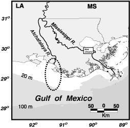
English: Atchafalaya River, Louisiana |
||||||
| Izvor |
Modified from USGS location map at [1]
|
||||||
| Autor | |||||||

Licenciranje
This image is in the public domain in the United States because it only contains materials that originally came from the United States Geological Survey, an agency of the United States Department of the Interior. For more information, see the official USGS copyright policy.
|
Izvorna evidencija postavljanja
Izvorna stranica s opisom bila je ovdje. Niže navedena suradnička imena odnose se na en.wikipedia.
- 2005-09-02 19:12 Dananderson 254×250×4 (6978 bytes) Atchafalaya River, Louisiana Modified from USGS location map at [http://gulfsci.usgs.gov/missriv/reports/ofrshelf/objectives.html] {{PD-USGov-Interior-USGS}}
Historija datoteke
Kliknite na datum/vrijeme da biste vidjeli tadašnju verziju datoteke.
| Datum/vrijeme | Minijatura | Dimenzije | Korisnik | Komentar | |
|---|---|---|---|---|---|
| aktualna | 15:05, 9 decembar 2007 | | 254 × 250 (7 kB) | Tokek~commonswiki | {{Information |Description={{en|Atchafalaya River, Louisiana Modified from USGS location map at [http://gulfsci.usgs.gov/missriv/reports/ofrshelf/objectives.html] PD-USGov}} |Source=Transfered from [http://en.wikipedia.org en.wikipedia] Transfer was st |
Upotreba datoteke
Sljedeća stranica koristi ovu datoteku:
Globalna upotreba datoteke
Ovu datoteku upotrebljavaju i sljedeći projekti:
- Upotreba na projektu de.wikipedia.org
- Upotreba na projektu en.wikipedia.org
- Upotreba na projektu es.wikipedia.org
- Upotreba na projektu fr.wikipedia.org
- Upotreba na projektu hi.wikipedia.org
- Upotreba na projektu it.wikipedia.org
- Upotreba na projektu ko.wikipedia.org
- Upotreba na projektu nl.wikipedia.org
- Upotreba na projektu pl.wikipedia.org
- Upotreba na projektu www.wikidata.org
- Upotreba na projektu zh.wikipedia.org