Datoteka:Abu Reyhan Biruni-Earth Circumference.svg

Izvor: Wikipedija
Prijeđi na navigaciju Prijeđi na pretragu
Izvorna datoteka(SVG fajl, nominalno 1.000 × 900 piksela, veličina fajla: 16 kB)

Ova datoteka je s projekta Vikimedijina ostava i može se upotrebljavati i na drugim projektima. Ispod su prikazane informacije s njene opisne stranice.

Opis izmjene

Opis
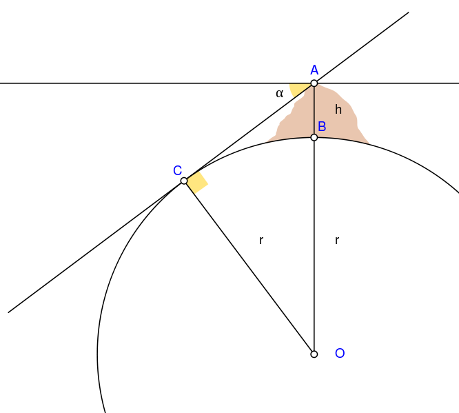
English: Biruni (973 - 1048) developed a new method using trigonometric calculations to compute earth's radius and circumference based on the angle between the horizontal line and true horizon from a mountain top with known height. He calculated the height of the mountain by going to two points at sea level with a known distance apart and then measuring the angle between the plain and the top of the mountain for both points.

Biruni's estimate of 6,339.9 km for the Earth radius had an error of 0.0026 and was 16.8 km less than the current value of 6,356.7 km. The idea came to him when he was on top of a tall mountain near Nandana in Pakistan. He measured the dip angle using an astrolabe and he applied to the law of sines formula. He also made use of algebra in his calculation.

  • A = Highest point of mountain
  • B = Lowest point of mountain
  • h = Height of the mountain
  • C = Lowest point of true horizon visible from point A
  • O = Centre of Earth
  • α = Dip angle
  • r = Earth's radius

Solution:
The angle AOC = α.
AO=(r+h) is the hypotenuse in triangle AOC.
r=(r+h)·cos(α)
Then the right side can be simplified to find r.

r=h·cos(α)/(1-cos(α))


Français : Biruni (973-1048) développa une nouvelle méthode utilisant la trigonométrie pour calculer le rayon et la ciconférence de la Terre, basée sur l'angle entre la ligne horizontale et l'horizon réel depuis le sommet d'une montagne de hauteur connue. Il calcula la hauteur de la montagne en se rendant en deux points situés au niveau de la mer dont l'écartement était connu, puis en mesurant l'angle entre la ligne horizontale formée par les deux points au niveau de la mer et le sommet de la montagne, et ceci depuis chacun des deux points.

L'estimation de Biruni de 6 339,9 km pour le rayon de la Terre comportait une erreur de 0,26 %, soit une valeur inférieure de 16,8 km par rapport à la valeur actuelle de 6 356,7 km. L'idée lui était venue alors qu'il se trouvait au sommet d'une haute montagne, près de Nandana en Inde. Il mesura l'angle d'incinaison avec un astrolabe et il appliqua la formule des sinus. Il fit également usage de l'algèbre pour ses calculs.

  • A = point culminant de la montagne
  • B = point le plus bas de la montagne
  • h = hauteur de la montagne
  • C = point le plus bas de l'horizon vrai visible du point A
  • O = Centre de la Terre
  • α = angle d'inclinaison
  • r = rayon de la Terre

Solution :
L'angle AOC = α.
AO=(r+h) est l'hypothénuse du triangle AOC.
r=(r+h)·cos(α)
Puis le côté droit se simplifie pour trouver r.

r=h·cos(α)/(1-cos(α))


Datum
Izvor Vlastito djelo Using Geogebra and Inkscape
Autor Nevit Dilmen
SVG genesis
InfoField
 
Izvorni kôd ove SVG datoteke je valjan.
 
Ova je vektorska slika napravljena programom Inkscape.
 
and with GeoGebra.
 
 This geometry uses embedded text that can be easily translated using a text editor.

Licenciranje

Ja, vlasnik autorskog prava ovog djela, ovdje ga objavljujem pod sljedećom licencom:
w:bs:Creative Commons
pripisivanje dijeljenje pod istim uslovima
Ova datoteka dostupna je pod licencom Creative Commons Attribution-Share Alike 3.0 Unported licencom.
Slobodno smijete:
  • dijeliti – umnožavati, raspodjeljivati i prenositi djelo
  • prerađivati – prilagođavati djelo
Pod sljedećim uslovima:
  • pripisivanje – Morate pripisati odgovarajuće autorske zasluge, osigurati link ka licenci i naznačiti jesu li napravljene izmjene. To možete uraditi na bilo koji razumni način, ali ne tako da se sugerira da davalac licence odobrava Vas ili Vašu upotrebu njegovog djela.
  • dijeljenje pod istim uslovima – Ako mijenjate, transformišete ili nadograđujete ovaj materijal, morate ga objaviti i distribuirati samo pod istom ili sličnom licencom poput ove.

Opisi

Dodajte objašnjenje u jednom redu što predstavlja ova datoteka

Predmeti pokazani na ovoj datoteci

prikazuje

Ovo svojstvo ima vrijednost, ali nije poznato

skraćeno ime autora Srpski (transliteracija): Nevit Dilmen
Vikimedija Srpski (transliteracija): Nevit

izvor datoteke Srpski (transliteracija)

sopstveno delo Srpski (transliteracija)

vrsta medija na Internetu Serbian (Latin script)

image/svg+xml

kontrolna suma Srpski (transliteracija)

4dd53114d5cd203e9b0011067229c31d0c5ea202

veličina podatka Srpski (transliteracija)

16.607 Bajt

900 piksel

1.000 piksel

Historija datoteke

Kliknite na datum/vrijeme da biste vidjeli tadašnju verziju datoteke.

Datum/vrijemeMinijaturaDimenzijeKorisnikKomentar
aktualna07:25, 2 maj 2010Minijatura verzije (07:25, 2 maj 2010)1.000 × 900 (16 kB)NevitCrop
07:21, 2 maj 2010Minijatura verzije (07:21, 2 maj 2010)1.390 × 1.220 (16 kB)NevitYellow removed
07:19, 2 maj 2010Minijatura verzije (07:19, 2 maj 2010)1.390 × 1.220 (16 kB)NevitImage version
07:18, 2 maj 2010Minijatura verzije (07:18, 2 maj 2010)640 × 480 (22 kB)Nevit{{Information |Description={{en|1=Biruni (973 - 1048) developed a new method using trigonometric calculations to compute earth's circumference based on the angle between the horizontal line and true horizon from a mountain top with known height. He calcu

Sljedeća stranica koristi ovu datoteku:

Globalna upotreba datoteke

Ovu datoteku upotrebljavaju i sljedeći projekti:

Potpunija globalna upotreba datoteke

Metapodaci