Datoteka:Europe 814.png
Prijeđi na navigaciju
Prijeđi na pretragu

Veličina ovog prikaza: 777 × 600 piksela. Druge rezolucije: 311 × 240 piksela | 622 × 480 piksela | 995 × 768 piksela | 1.280 × 988 piksela | 1.393 × 1.075 piksela.
Izvorna datoteka (1.393 × 1.075 piksela, veličina datoteke/fajla: 169 kB, MIME tip: image/png)

Opis izmjene
| Opis |
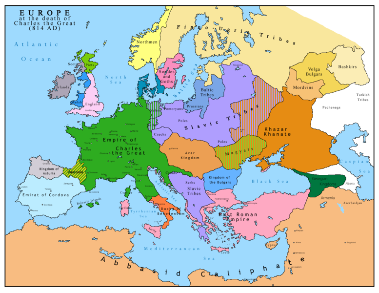
English: Map of Europe after the death of Charles the Great (814 AD). Original map made by Charles Colbeck, The Public Schools Historical Atlas (1905). |
|||
| Datum | 2009-04-15. Source date: 1905 by Longmans, Green; New York, London, Bombay 1905. | |||
| Izvor | Own work based on: Europe 814.jpg | |||
| Autor | Bukkia (razgovor · doprinos) | |||
| Ostale verzije |
|


Licenciranje
| Ja, vlasnik autorskog prava ovog djela, objavljujem ovaj rad u javno vlasništvo. Ovo se primjenjuje u cijelom svijetu. U nekim državama ovo zakonski nije moguće; u tom slučaju: Ja dopuštam svima pravo korištenja ovog rada u bilo koju svrhu, bez ikakvih uslova, osim ako su takvi uslovi zakonski neophodni. |
_en.png)
.png)
.jpg)
Historija datoteke
Kliknite na datum/vrijeme da biste vidjeli tadašnju verziju datoteke.
| Datum/vrijeme | Minijatura | Dimenzije | Korisnik | Komentar | |
|---|---|---|---|---|---|
| aktualna | 13:09, 26 april 2023 | | 1.393 × 1.075 (169 kB) | OrionNimrod | Reverted to version as of 13:52, 23 December 2015 (UTC) restore |
| 18:09, 2 maj 2019 |  | 1.370 × 1.047 (124 kB) | Julieta39 | Slavs also in the Avars and Bulgars kingdoms | |
| 15:52, 23 decembar 2015 |  | 1.393 × 1.075 (169 kB) | Ercwlff | at that time armenia was already part of Arab caliphate.. and there were several Georgian kingdoms or principalities in the north of them | |
| 15:52, 8 juni 2015 |  | 1.393 × 1.075 (157 kB) | Zorion | Vasconia in rebellion | |
| 19:49, 28 maj 2015 |  | 1.393 × 1.075 (156 kB) | Zorion | From 812 to 824, Vasconia was ruled by Vascons (sourced can be found anywhere in spanish, basque or french). This map was wrong for that specific year. Seems that historian wanted to credit a famous king but, he was dead when Wasconia got back under th... | |
| 17:58, 24 august 2014 |  | 1.393 × 1.075 (230 kB) | Martin H. | Reverted to version as of 14:53, 31 January 2010: File is consistent with its source file File:Europe 814.jpg; change conflicts with en:Duchy_of_Vasconia#Carolingian duchy (769–864) | |
| 16:42, 24 august 2014 |  | 1.393 × 1.075 (156 kB) | Zorion | Vasconia was independant from frankish kingdom until 824 | |
| 16:53, 31 januar 2010 |  | 1.393 × 1.075 (230 kB) | Bukkia | == {{int:filedesc}} == {{Information |Description={{it|1=Mappa dell'Europa alla morte di Carlo Magno (814 d.C.)}} {{en|1=Map of Europe after the death of Charles the Great (814 AD, in Italian)}} |Source=Based on File:Europe 814.jpg |Author=[[user:Buk |
Upotreba datoteke
Sljedeća stranica koristi ovu datoteku:
Globalna upotreba datoteke
Ovu datoteku upotrebljavaju i sljedeći projekti:
- Upotreba na projektu arz.wikipedia.org
- Upotreba na projektu bo.wikipedia.org
- Upotreba na projektu da.wikipedia.org
- Upotreba na projektu de.wikipedia.org
- Upotreba na projektu el.wikipedia.org
- Upotreba na projektu en.wikipedia.org
- Upotreba na projektu es.wikipedia.org
- Upotreba na projektu fa.wikipedia.org
- Upotreba na projektu fr.wikipedia.org
- Upotreba na projektu gl.wikipedia.org
- Upotreba na projektu he.wikipedia.org
- Upotreba na projektu hu.wikipedia.org
- Upotreba na projektu hy.wikipedia.org
- Upotreba na projektu id.wikipedia.org
- Upotreba na projektu it.wikipedia.org
- Upotreba na projektu ko.wikipedia.org
- Upotreba na projektu lmo.wikipedia.org
- Upotreba na projektu lv.wikipedia.org
- Upotreba na projektu mk.wikipedia.org
- Upotreba na projektu pl.wikipedia.org
- Upotreba na projektu ro.wikipedia.org
- Upotreba na projektu sr.wikipedia.org
- Upotreba na projektu sw.wikipedia.org
- Upotreba na projektu uk.wikipedia.org