Datoteka:Serbia-WW1-4.jpg
Prijeđi na navigaciju
Prijeđi na pretragu
Veličina ovog prikaza: 799 × 271 piksela. Druge rezolucije: 320 × 109 piksela | 1.023 × 347 piksela.
Izvorna datoteka (1.023 × 347 piksela, veličina datoteke/fajla: 99 kB, MIME tip: image/jpeg)

|
This map has been uploaded by Electionworld from en.wikipedia.org to enable the |
Opis izmjene
| Opis |
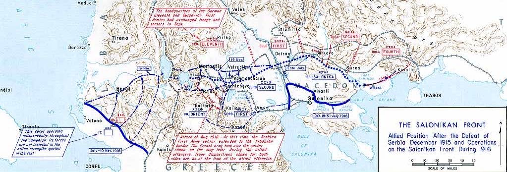
English: Operations at the border of Greece and Serbia, 1916.
his map was created by the Department of Military Art and Engineering, at the U.S. Military Academy (West Point). The initial version was created under the supervision of General Vincent Esposito in 1959. It is now available on the West Point |
||||||
| Datum | |||||||
| Izvor | West Point | ||||||
| Autor | General Vincent Esposito | ||||||
| Dopuštenje (Ponovna upotreba ove datoteke) |
|
||||||
| Ostale verzije |
  |
||||||

Historija datoteke
Kliknite na datum/vrijeme da biste vidjeli tadašnju verziju datoteke.
| Datum/vrijeme | Minijatura | Dimenzije | Korisnik | Komentar | |
|---|---|---|---|---|---|
| aktualna | 23:55, 21 decembar 2006 | 1.023 × 347 (99 kB) | Electionworld | {{ew|en|Cglassey}} == Summary == Operations at the border of Greece and Serbia, 1916. his map was created by the Department of Military Art and Engineering, at the U.S. Military Academy (West Point). The initial version was created under the supervision |
Upotreba datoteke
Sljedeća stranica koristi ovu datoteku:
Globalna upotreba datoteke
Ovu datoteku upotrebljavaju i sljedeći projekti:
- Upotreba na projektu ar.wikipedia.org
- Upotreba na projektu azb.wikipedia.org
- Upotreba na projektu az.wikipedia.org
- Upotreba na projektu be-tarask.wikipedia.org
- Upotreba na projektu be.wikipedia.org
- Upotreba na projektu bg.wikipedia.org
- Upotreba na projektu bs.wikipedia.org
- Upotreba na projektu ca.wikipedia.org
- Upotreba na projektu de.wikipedia.org
- Upotreba na projektu el.wikipedia.org
- Upotreba na projektu en.wikipedia.org
- History of modern Macedonia (Greece)
- Maurice Sarrail
- Macedonian front
- Battle of Doiran (1917)
- Greece during World War I
- Monastir offensive
- Autonomous Province of Korçë
- Bulgarian occupation of Albania
- World War I in Albania
- Battle of the Crna Bend (1917)
- User:GerardM/Battles including the Ottoman Empire
- User:Falcaorib
- User:BoDr12/sandbox
- Upotreba na projektu es.wikipedia.org
- Upotreba na projektu fa.wikipedia.org
- Upotreba na projektu fr.wikipedia.org
- Upotreba na projektu he.wikipedia.org
- Upotreba na projektu hr.wikipedia.org
- Upotreba na projektu hu.wikipedia.org