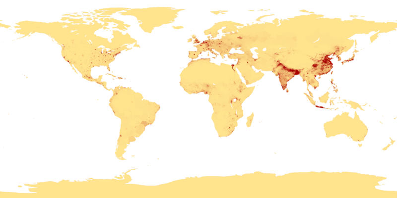
Datoteka:Population density.png
Prijeđi na navigaciju
Prijeđi na pretragu

Veličina ovog prikaza: 800 × 400 piksela. Druge rezolucije: 320 × 160 piksela | 640 × 320 piksela | 1.024 × 512 piksela | 1.280 × 640 piksela | 2.560 × 1.280 piksela | 4.320 × 2.160 piksela.
Izvorna datoteka (4.320 × 2.160 piksela, veličina datoteke/fajla: 522 kB, MIME tip: image/png)
Historija datoteke
Kliknite na datum/vrijeme da biste vidjeli tadašnju verziju datoteke.
| Datum/vrijeme | Minijatura | Dimenzije | Korisnik | Komentar | |
|---|---|---|---|---|---|
| aktualna | 02:41, 11 april 2013 |  | 4.320 × 2.160 (522 kB) | Jahoe | Re-downloaded original from http://eoimages.gsfc.nasa.gov/images/imagerecords/53000/53005/population_density.tif, re-converted to PNG (preserving alpha channel) using tiff2png (by Willem van Schaik and Greg Roelofs). Removed rgb pixel values from fully... |
| 05:41, 27 februar 2007 |  | 4.320 × 2.160 (915 kB) | Keenan Pepper | This image shows the number of people per square kilometer around the world in 1994. The data were derived from population records based on political divisions such as states, provinces, and counties. The image was taken from [http://visibleearth.nasa.go |
Upotreba datoteke
Sljedećih 4 stranica koriste ovu datoteku:
Globalna upotreba datoteke
Ovu datoteku upotrebljavaju i sljedeći projekti:
- Upotreba na projektu als.wikipedia.org
- Upotreba na projektu an.wikipedia.org
- Upotreba na projektu ar.wikipedia.org
- Upotreba na projektu ast.wikipedia.org
- Upotreba na projektu az.wikipedia.org
- Upotreba na projektu be-tarask.wikipedia.org
- Upotreba na projektu be.wikipedia.org
- Upotreba na projektu bg.wikipedia.org
- Upotreba na projektu bh.wikipedia.org
- Upotreba na projektu bn.wikipedia.org
- Upotreba na projektu bs.wikipedia.org
- Upotreba na projektu ca.wikipedia.org
- Upotreba na projektu ce.wikipedia.org
- Upotreba na projektu ckb.wikipedia.org
- Upotreba na projektu cu.wikipedia.org
- Upotreba na projektu cv.wikipedia.org
- Upotreba na projektu da.wikipedia.org
- Upotreba na projektu da.wikibooks.org
- Upotreba na projektu de.wikipedia.org
- Upotreba na projektu dsb.wikipedia.org
- Upotreba na projektu el.wikipedia.org
- Upotreba na projektu en.wikipedia.org
- Upotreba na projektu en.wikiquote.org
- Upotreba na projektu eo.wikipedia.org
- Upotreba na projektu es.wikipedia.org


