Datoteka:Odoacer 480ad.jpg

Izvorna datoteka (900 × 545 piksela, veličina datoteke/fajla: 701 kB, MIME tip: image/jpeg)

|
This historical map image could be re-created using vector graphics as an SVG file. This has several advantages; see Commons:Media for cleanup for more information. If an SVG form of this image is available, please upload it and afterwards replace this template with
{{vector version available|new image name}}.
It is recommended to name the SVG file “Odoacer 480ad.svg”—then the template Vector version available (or Vva) does not need the new image name parameter. |


Opis izmjene
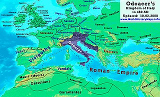
| Opis | Odoacer's Kingdom of Italy in 480 AD. |
| Datum | |
| Izvor | Vlastito djelo |
| Autor | Thomas Lessman (Contact!) |
| Dopuštenje (Ponovna upotreba ove datoteke) |
Ja, vlasnik autorskog prava ovog djela, ovdje ga objavljujem pod sljedećom licencom: Ova datoteka dostupna je pod licencom Creative Commons Attribution-Share Alike 3.0 Unported licencom.
|
| Ostale verzije | See Below |
Map Summary
Original Source URL: http://www.thomaslessman.com/History/images/East-Hem_480ad.jpg or www.WorldHistoryMaps.info
This map of the Kingdom of Odoacer in 480 AD is a zoomed-in version of Thomas Lessman's map of the East-Hem 480 AD, also available at www.WorldHistoryMaps.info.
The highlighted areas represent Odoacer's Kingdom of Italy, after the capture of Italy (476), conquest of Sicily from the Vandals (477) and the annexation of Dalmatia after the assassination of Emperor Julius Nepos (480).
Map Source References
Remember, sources often conflict with each other. This map is only as accurate as the information that is available to me. To report any errors or to help further this work, please click here, or email Thomas Lessman at talessman@yis.us
References for information contained in this map:
Other Maps by Thomas Lessman
| Maps of the eastern hemisphere showing history
Bold dates are available on Wikimedia or Wikipedia. | ||
| Primeval | ||
| Ancient
|
·| 600 BC | 550 BC | 527 BC | 500 BC |
400 BC | ·| 1 AD | 50 AD | 100 AD | 200 AD | 300 AD | | |
| Medieval |
·| 500 AD | 565 AD | 600 AD | 700 AD | | |
| Modern |
·| 1500 AD | · * For historical maps of the whole world, | |
Historija datoteke
Kliknite na datum/vrijeme da biste vidjeli tadašnju verziju datoteke.
| Datum/vrijeme | Minijatura | Dimenzije | Korisnik | Komentar | |
|---|---|---|---|---|---|
| aktualna | 21:50, 23 oktobar 2022 | | 900 × 545 (701 kB) | Gyalu22 | Reverted bad faith edit. The Westermanns Atlas doesn't show the Carpi |
| 18:05, 15 septembar 2015 |  | 900 × 545 (727 kB) | Spiridon Ion Cepleanu | Details about the low-Danube according with H.E.Stier's (dir.) Grosser Atlas zur Weltgeschichte, Westermann 1985. | |
| 23:40, 2 oktobar 2008 |  | 900 × 545 (701 kB) | Talessman | {{Information |Description= |Source= |Date= |Author= |Permission= |other_versions= }} | |
| 12:29, 10 maj 2008 |  | 1.402 × 1.023 (380 kB) | Talessman | {{Information |Description=<big>'''The Odoacer's Kingdom of Italy in 477 AD.'''</big> |Source=Self-made |Author=Thomas Lessman |Permission={{self|cc-by-sa-3.0}} }} |
Upotreba datoteke
Sljedećih 2 stranica koriste ovu datoteku:
Globalna upotreba datoteke
Ovu datoteku upotrebljavaju i sljedeći projekti:
- Upotreba na projektu azb.wikipedia.org
- Upotreba na projektu ba.wikipedia.org
- Upotreba na projektu bg.wikipedia.org
- Upotreba na projektu br.wikipedia.org
- Upotreba na projektu ca.wikipedia.org
- Upotreba na projektu de.wikipedia.org
- Upotreba na projektu el.wikipedia.org
- Upotreba na projektu en.wikipedia.org
- Upotreba na projektu es.wikipedia.org
- Upotreba na projektu eu.wikipedia.org
- Upotreba na projektu fi.wikipedia.org
- Upotreba na projektu fr.wikipedia.org
- Upotreba na projektu fy.wikipedia.org
- Upotreba na projektu hy.wikipedia.org
- Upotreba na projektu ia.wikipedia.org
- Upotreba na projektu it.wikipedia.org
- Upotreba na projektu ja.wikipedia.org
- Upotreba na projektu ko.wikipedia.org
- Upotreba na projektu li.wikipedia.org
- Upotreba na projektu lmo.wikipedia.org
- Upotreba na projektu lt.wikipedia.org
- Upotreba na projektu lv.wikipedia.org
- Upotreba na projektu nds.wikipedia.org
- Upotreba na projektu nl.wikipedia.org
- Upotreba na projektu pl.wikipedia.org