Datoteka:KYphysiography.jpg
Prijeđi na navigaciju
Prijeđi na pretragu

Veličina ovog prikaza: 800 × 353 piksela. Druge rezolucije: 320 × 141 piksela | 824 × 364 piksela.
Izvorna datoteka (824 × 364 piksela, veličina datoteke/fajla: 159 kB, MIME tip: image/jpeg)

|
This map image could be re-created using vector graphics as an SVG file. This has several advantages; see Commons:Media for cleanup for more information. If an SVG form of this image is available, please upload it and afterwards replace this template with
{{vector version available|new image name}}.
It is recommended to name the SVG file “KYphysiography.svg”—then the template Vector version available (or Vva) does not need the new image name parameter. |


Opis izmjene
| Opis |
English: I created this image using Wikipedia's map of Kentucky counties.
|
| Datum | 1. maj 2007. (izvorni datum postavljanja) |
| Izvor | Transferred from en.wikipedia to Commons by byankno1. |
| Autor | Lamontacranston na Wikipedia na Engleski |
Licenciranje
| Ovaj rad je objavljen u javno vlasništvo od strane autora Lamontacranston na Wikipedia na Engleski. Ovo se primjenjuje širom svijeta. U nekim državama ovo zakonski nije moguće; u tom slučaju: Lamontacranston dopušta svima pravo korištenja ovog rada u bilo koju svrhu, bez ikakvih uslova, osim ako su takvi uslovi zakonski neophodni. |
Izvorna evidencija postavljanja
The original description page was here. All following user names refer to en.wikipedia.
- 2007-05-01 00:01 Lamontacranston 824×364× (162592 bytes) Bigger fonts. I created this image.
- 2007-04-30 23:54 Lamontacranston 824×364× (154693 bytes) Added text, improved edges, slightly lightened colors. I created the original.
- 2006-09-09 19:16 Lamontacranston 824×364× (55286 bytes) I created this image using Wikipedia's map of Kentucky counties.
Historija datoteke
Kliknite na datum/vrijeme da biste vidjeli tadašnju verziju datoteke.
| Datum/vrijeme | Minijatura | Dimenzije | Korisnik | Komentar | |
|---|---|---|---|---|---|
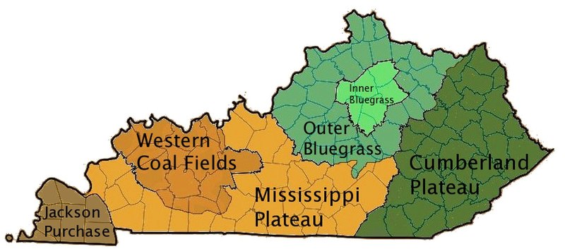
| aktualna | 18:36, 18 novembar 2008 | | 824 × 364 (159 kB) | EpcotMagic | {{Information |Description={{en|I created this image using Wikipedia's map of Kentucky counties. *Dark green - Eastern Kentucky Coal fields (Cumberland Plateau) *Green - Outer Bluegrass *Light Green - Inner Bluegrass *Light Brown - Mississippi (Pennyroyal |
Upotreba datoteke
Sljedeća stranica koristi ovu datoteku:
Globalna upotreba datoteke
Ovu datoteku upotrebljavaju i sljedeći projekti:
- Upotreba na projektu ar.wikipedia.org
- Upotreba na projektu de.wikipedia.org
- Upotreba na projektu el.wikipedia.org
- Upotreba na projektu en.wikipedia.org
- Upotreba na projektu es.wikipedia.org
- Upotreba na projektu fi.wikipedia.org
- Upotreba na projektu he.wikipedia.org
- Upotreba na projektu ia.wikipedia.org
- Upotreba na projektu id.wikipedia.org
- Upotreba na projektu it.wikipedia.org
- Upotreba na projektu ja.wikipedia.org
- Upotreba na projektu no.wikipedia.org
- Upotreba na projektu pt.wikipedia.org
- Upotreba na projektu simple.wikipedia.org
- Upotreba na projektu sv.wikipedia.org
- Upotreba na projektu vi.wikipedia.org
- Upotreba na projektu zh.wikipedia.org