Datoteka:International E Road Network green.png
Prijeđi na navigaciju
Prijeđi na pretragu

Veličina ovog prikaza: 800 × 571 piksela. Druge rezolucije: 320 × 229 piksela | 640 × 457 piksela.
Izvorna datoteka (840 × 600 piksela, veličina datoteke/fajla: 38 kB, MIME tip: image/png)

|
This road map image could be re-created using vector graphics as an SVG file. This has several advantages; see Commons:Media for cleanup for more information. If an SVG form of this image is available, please upload it and afterwards replace this template with
{{vector version available|new image name}}.
It is recommended to name the SVG file “International E Road Network green.svg”—then the template Vector version available (or Vva) does not need the new image name parameter. |
Opis izmjene
| Opis |
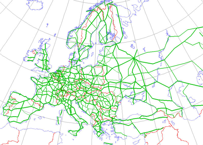
English: Map generated using coastline/boundary data from World Data Bank, and locations from http://www.world-gazetteer.com/. Straight lines connect control cities, no attempt to follow the real road. Roads color has been changed to green.
Deutsch: Diese Karte wurde mit den Küsten- und Grenzverlaufsdaten aus der World Data Bank und mit den Koordinaten aus http://www.world-gazetteer.com/ erstellt. Die Städte sind durch gerade Linien vebunden die nicht unbedingt den realen Straßenverlauf wiedergeben. Die Farbe der Straßen wurde in grün geändert.
Türkçe: Harita oluşturulken sahilyolu ve sınırlar bilgisi Dünya Bilgi Bankası'ndan ve lokasyonlar http://www.world-gazetteer.com/ adlı siteden alınmıştır. Düz çizgiler kontrol şehirlerini bağlar. Yol rengi yeşile değiştirildi. |
| Izvor | http://en.wikipedia.org/wiki/Image:International_E_Road_Network.png |
| Autor | Kjhskj75 |
Licenciranje
| Ja, vlasnik autorskog prava ovog djela, objavljujem ovaj rad u javno vlasništvo. Ovo se primjenjuje u cijelom svijetu. U nekim državama ovo zakonski nije moguće; u tom slučaju: Ja dopuštam svima pravo korištenja ovog rada u bilo koju svrhu, bez ikakvih uslova, osim ako su takvi uslovi zakonski neophodni. |
Historija datoteke
Kliknite na datum/vrijeme da biste vidjeli tadašnju verziju datoteke.
| Datum/vrijeme | Minijatura | Dimenzije | Korisnik | Komentar | |
|---|---|---|---|---|---|
| aktualna | 18:09, 13 maj 2008 | | 840 × 600 (38 kB) | Jklamo | Albania update |
| 14:07, 22 decembar 2007 |  | 840 × 600 (39 kB) | BIL | == Description == {{Information |Description=Map generated using coastline/boundary data from World Data Bank, and locations from www.world-gazetteer.com. Straight lines connect control cities, no attempt to follow the real road. Roads color has been chan | |
| 22:03, 7 oktobar 2007 |  | 840 × 600 (33 kB) | The RedBurn | All e-roads in green. | |
| 21:55, 7 oktobar 2007 |  | 840 × 600 (34 kB) | The RedBurn | {{Information |Description=Map generated using coastline/boundary data from World Data Bank, and locations from www.world-gazetteer.com. Straight lines connect control cities, no attempt to follow the real road. Roads color has been changed to green. |Sou |
Upotreba datoteke
Sljedećih 5 stranica koriste ovu datoteku:
Globalna upotreba datoteke
Ovu datoteku upotrebljavaju i sljedeći projekti:
- Upotreba na projektu ar.wikipedia.org
- Upotreba na projektu be.wikipedia.org
- Upotreba na projektu bg.wikipedia.org
- Европейски път
- Европейски път Е79
- Европейски път Е70
- Европейски път Е80
- Европейски път Е67
- Европейски път Е85
- Европейски път Е851
- Европейски път Е671
- Шаблон:Европейска пътна мрежа
- Европейски път Е81
- Европейски път Е804
- Европейски път Е763
- Европейски път Е762
- Европейски път Е87
- Европейски път Е772
- Европейски път Е83
- Европейски път Е871
- Европейски път Е75
- Европейски път Е773
- Европейски път Е11
- Европейски път Е51
- Европейски път Е761
- Европейски път Е17
- Европейски път Е76
- Европейски път Е82
- Европейски път Е84
- Европейски път Е86
- Европейски път E01
- Европейски път E03
- Европейски път E04
- Европейски път E05
- Европейски път E06
- Европейски път E07
- Европейски път E08
- Европейски път E09
- Европейски път E10
- Европейски път E12
- Европейски път E13
- Европейски път E14