Datoteka:Hindutagh-pass-aksai-chin-center2-1873.jpg
Prijeđi na navigaciju
Prijeđi na pretragu

Veličina ovog prikaza: 420 × 600 piksela. Druge rezolucije: 168 × 240 piksela | 336 × 480 piksela | 537 × 768 piksela | 717 × 1.024 piksela | 1.386 × 1.980 piksela.
Izvorna datoteka (1.386 × 1.980 piksela, veličina datoteke/fajla: 409 kB, MIME tip: image/jpeg)
Opis izmjene

|
Ova datoteka je premještena na Wikimedijin Zajednički poslužitelj s en.wikipedia uz pomoć bota. Svi izvorni podaci još uvijek su prisutni te zahtijevaju provjeru. Moguće je da postoje greške u nekim ili svim poljima s podacima. Podaci na ovoj datoteci ne bi se trebali smatrati vjerodostojnima i datoteku ne bi trebalo rabiti sve dok ne bude provjerena i dok ne budu učinjeni svi potrebi ispravci. Jednom kad se provjera dovrši, ovaj bi predložak trebao biti uklonjen. Za detalje o ovoj datoteci, pogledajte niže. Provjerite odmah! |
| Opis |
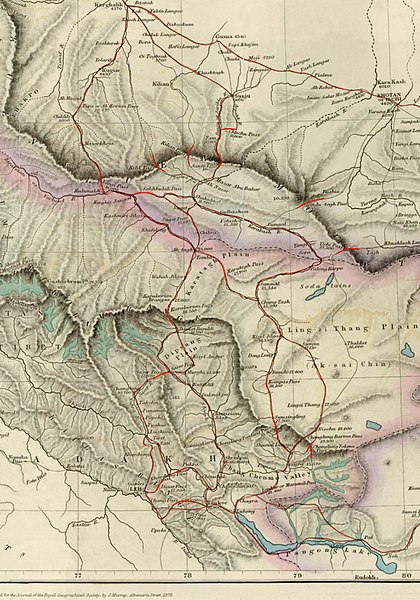
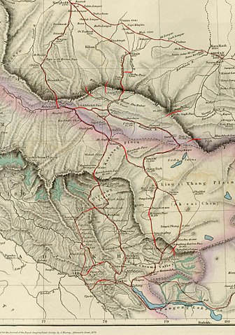
English: Image of map of the Baltistan, Aksai Chin, Chinese Turkestan in maps of Central Asia. The international border between the British Indian Empire (including the Kashmir region) and Chinese Turkestan is shown two-toned purple and pink. From the article, "On the Geographical Results of the Mission to Kashghar, under Sir T. Douglas Forsyth in 1873-74" by H. Trotter
Journal of the Royal Geographical Society of London, Vol. 48. (1878), pp. 173-234. Downloaded, resized to 33% of original size and annotated by Fowler&fowler«Talk» 23:52, 8 July 2007 (UTC) |
| Izvor | Article= "On the Geographical Results of the Mission to Kashghar, under Sir T. Douglas Forsyth in 1873-74" by H. Trotter, Journal of the Royal Geographical Society of London, Vol. 48. (1878), pp. 173-234. |
| Autor | H. Trotter |
| Ostale verzije |
.jpg)

Licenciranje
|
This is a faithful photographic reproduction of a two-dimensional, public domain work of art. The work of art itself is in the public domain for the following reason:
The official position taken by the Wikimedia Foundation is that "faithful reproductions of two-dimensional public domain works of art are public domain".
This photographic reproduction is therefore also considered to be in the public domain in the United States. In other jurisdictions, re-use of this content may be restricted; see Reuse of PD-Art photographs for details. |


Izvorna evidencija postavljanja
Izvorna stranica s opisom bila je ovdje. Niže navedena suradnička imena odnose se na en.wikipedia.
- 2007-07-08 23:50 Fowler&fowler 1386×1980× (419033 bytes) Image of map of Central Asia from the article, [http://www.jstor.org/stable/1798763 "On the Geographical Results of the Mission to Kashghar, under Sir T. Douglas Forsyth in 1873-74"] by H. Trotter ''Journ
| Annotations | This image is annotated: View the annotations at Commons |
Historija datoteke
Kliknite na datum/vrijeme da biste vidjeli tadašnju verziju datoteke.
| Datum/vrijeme | Minijatura | Dimenzije | Korisnik | Komentar | |
|---|---|---|---|---|---|
| aktualna | 23:49, 19 januar 2010 | | 1.386 × 1.980 (409 kB) | File Upload Bot (Magnus Manske) | {{BotMoveToCommons|en.wikipedia|year={{subst:CURRENTYEAR}}|month={{subst:CURRENTMONTHNAME}}|day={{subst:CURRENTDAY}}}} {{Information |Description={{en|Image of map of the Baltistan, Aksai Chin, Chinese Turkestan in maps of Central Asia. The internationa |
Upotreba datoteke
Sljedeća stranica koristi ovu datoteku:
Globalna upotreba datoteke
Ovu datoteku upotrebljavaju i sljedeći projekti:
- Upotreba na projektu as.wikipedia.org
- Upotreba na projektu en.wikipedia.org
- Upotreba na projektu es.wikipedia.org
- Upotreba na projektu fr.wikipedia.org
- Upotreba na projektu hi.wikipedia.org
- Upotreba na projektu it.wikipedia.org
- Upotreba na projektu no.wikipedia.org
- Upotreba na projektu or.wikipedia.org
- Upotreba na projektu pnb.wikipedia.org
- Upotreba na projektu ru.wikipedia.org
- Upotreba na projektu sl.wikipedia.org
- Upotreba na projektu te.wikipedia.org
- Upotreba na projektu uz.wikipedia.org
- Upotreba na projektu vi.wikipedia.org
- Upotreba na projektu www.wikidata.org
- Upotreba na projektu zh.wikipedia.org