Datoteka:Bahn-Streckenkarte Deutschland-06-2010.png

Izvorna datoteka (1.122 × 1.515 piksela, veličina datoteke/fajla: 680 kB, MIME tip: image/png)
| Opis |
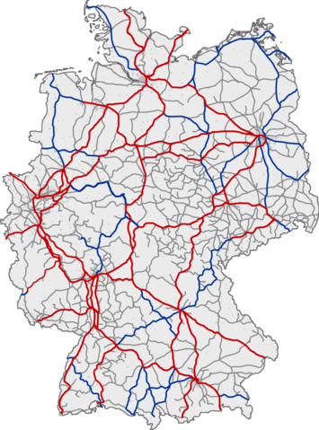
Deutsch: Eisenbahnnetz in Deutschland. Rot: ICE-Strecken; blau: IC/EC-Strecken; grau: sonstiger Personenverkehr
English: Railway network of Germany. Red: lines with InterCityExpress traffic; blue: lines with InterCity/EuroCity traffic; grey: lines with other passenger traffic
Français : Réseau ferré allemand. Rouge : lignes InterCityExpress (ICE); bleu : lignes InterCity/EuroCity; gris : autres lignes de transport de passagers
Magyar: Németország vasúthálózata ;vörös :Vasútvonal InterCityExpress közlekedéssel ;kék :Vasútvonal InterCity/EuroCity közlekedéssel ;szürke :Vasútvonal egyéb személyvonat forgalommal |
|||
| Datum | (UTC) | |||
| Izvor | ||||
| Autor |
|
|||
| Ostale verzije |
|


| Ovo je retuširana slika, što znači da je digitalno izmjenjena u odnosu na svoju izvornu inačicu. Izmjene: Aktualisiert. Izvornik se može vidjeti ovdje: Bahn-Streckenkarte Deutschland.png. Izmjene je napravio: YouthOfSword.
|
This image was generated with OpenGeoDB. The information there is placed in the public domain, images generated from OpenGeoDB are derivative works without passing the threshold of creativity, they are therefore also public domain.
| Ova slika je javno dobro („public domain“), jer sadrži samo opće informacije koje ne dostižu kreativni nivo potreban za copyright. In case this image would pass the threshold of originality, the copyright holder, allows the use of this image with the following conditions:
{{PD-ineligible}}
|
Izvorna evidencija postavljanja
This image was a derivative work of the following image:
- File:Bahn-Streckenkarte_Deutschland.png licensed with GFDL-OpenGeoDB, PD-ineligible
- 2006-05-02T01:06:28Z Qualle 1122x1515 (215324 Bytes) {{Information| |Description={{de|Eisenbahnnetz in Deutschland ;rot :ICE-Strecken ;blau :IC/EC-Strecken ;grau :sonstiger Personenverkehr}}{{en|Railway network of Germany ;red :lines with InterCityExpress traffic ;blue :lines w
Uploaded with derivativeFX
In order to reestablish file version continuity for those who still link to the older file File:Bahn-Streckenkarte_Deutschland.png, on February 16, 2011, the current version of this file has been uploaded as current version of File:Bahn-Streckenkarte_Deutschland.png to its location in Wikimedia Commons. --Qniemiec (talk) 02:16, 16 February 2011 (UTC)
Historija datoteke
Kliknite na datum/vrijeme da biste vidjeli tadašnju verziju datoteke.
| Datum/vrijeme | Minijatura | Dimenzije | Korisnik | Komentar | |
|---|---|---|---|---|---|
| aktualna | 13:58, 6 juni 2010 | | 1.122 × 1.515 (680 kB) | YouthOfSword | {{Information |Description={{de|Eisenbahnnetz in Deutschland ;rot :ICE-Strecken ;blau :IC/EC-Strecken ;grau :sonstiger Personenverkehr }} <br /> {{en|Railway network of Germany ;red :lines with InterCityExpress traffic ;blue :lines with InterCity/EuroCity |
Upotreba datoteke
Nema stranica koje koriste ovu datoteku.
Globalna upotreba datoteke
Ovu datoteku upotrebljavaju i sljedeći projekti:
- Upotreba na projektu de.wikipedia.org
- Upotreba na projektu en.wikipedia.org
- Upotreba na projektu fr.wiktionary.org
- Upotreba na projektu ja.wikipedia.org
- Upotreba na projektu zh.wikipedia.org