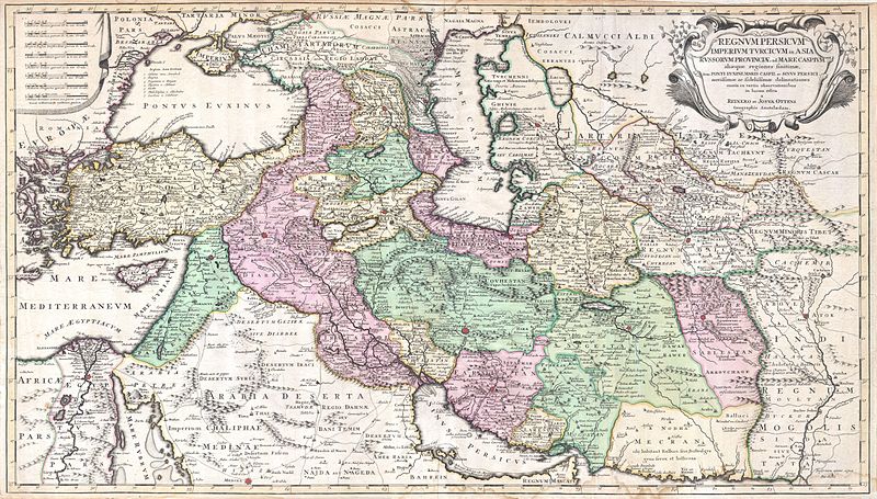
Datoteka:1730 Ottens Map of Persia (Iran, Iraq, Turkey) - Geographicus - RegnumPersicum-ottens-1730.jpg
Prijeđi na navigaciju
Prijeđi na pretragu

Veličina ovog prikaza: 800 × 455 piksela. Druge rezolucije: 320 × 182 piksela | 640 × 364 piksela | 1.024 × 583 piksela | 1.280 × 728 piksela | 2.560 × 1.457 piksela | 5.000 × 2.845 piksela.
Izvorna datoteka (5.000 × 2.845 piksela, veličina datoteke/fajla: 3,6 MB, MIME tip: image/jpeg)
Historija datoteke
Kliknite na datum/vrijeme da biste vidjeli tadašnju verziju datoteke.
| Datum/vrijeme | Minijatura | Dimenzije | Korisnik | Komentar | |
|---|---|---|---|---|---|
| aktualna | 18:00, 16 mart 2011 |  | 5.000 × 2.845 (3,6 MB) | BotMultichill | {{subst:User:Multichill/Geographicus |link=http://www.geographicus.com/P/AntiqueMap/RegnumPersicum-ottens-1730 |product_name=1730 Ottens Map of Persia (Iran, Iraq, Turkey) |map_title=Regnum Persicum Imperium Turcicum in Asia Russorum Provinciae and Mare C |
Upotreba datoteke
Sljedećih 2 stranica koriste ovu datoteku:
Globalna upotreba datoteke
Ovu datoteku upotrebljavaju i sljedeći projekti:
- Upotreba na projektu ar.wikipedia.org
- Upotreba na projektu azb.wikipedia.org
- Upotreba na projektu az.wikipedia.org
- Upotreba na projektu bs.wikipedia.org
- Upotreba na projektu ca.wikipedia.org
- Upotreba na projektu da.wikipedia.org
- Upotreba na projektu de.wikipedia.org
- Upotreba na projektu el.wikipedia.org
- Upotreba na projektu en.wikipedia.org
- Upotreba na projektu es.wikipedia.org
- Upotreba na projektu et.wikipedia.org
- Upotreba na projektu fa.wikipedia.org
- Upotreba na projektu hr.wikipedia.org
- Upotreba na projektu hy.wikipedia.org
- Upotreba na projektu it.wikipedia.org
- Upotreba na projektu ka.wikipedia.org
- Upotreba na projektu ko.wikipedia.org
- Upotreba na projektu mk.wikipedia.org
- Upotreba na projektu ms.wikipedia.org
- Upotreba na projektu nl.wikipedia.org
- Upotreba na projektu pnb.wikipedia.org
- Upotreba na projektu pt.wikipedia.org
- Upotreba na projektu ru.wikipedia.org
- Upotreba na projektu sr.wikipedia.org
- Upotreba na projektu tr.wikipedia.org
